


GR20 Corsica, France - Europe's Toughest Trek
The GR20 or grande randonnée” is sometimes described as the most difficult and technical long-distance trail in Europe, for serious walkers who want a challenge. We had studied various guide books and read up in advance on the internet. The walk is 190km long over rugged terrain with a total elevation of 12,000 m, taking about 15 days with tough climbs each day. We decided to walk from the north to the south of the island as it seemed more popular, the guide book goes that way, also this has the advantage of the hardest days walking being completed first. However, if walking in early summer, the advantage of walking south to north would be to allow the snow in the higher mountains in the north more time to melt, other hikers see the south as fitness training before arriving in the north. We met many people going both ways. Apparently in 2017 approximately 15,000 walkers attempted the walk, with a dropout rate of about 40%.
In January when we were booking the trip through Corsican Aventure, we were planning to depart on 15th June, but were advised by the company that snow may still be present on the mountains so it was preferable to leave later. Therefore, we booked to depart from Calenzana on Sunday 23rd June. Normally we would make the booking ourselves, but on this occasion thought it would be difficult to achieve as we would be staying at remote refuges which only open in the Summer, together with our lack of French. A combination of 3 hotels, tents in the vicinity of the refuges and a couple of dormitories were booked, also evening meal, a packed lunch and breakfast was included in the price. We were pleased to have the food booked and paid for in advance. We were told no bedding is provided, and to bring sleeping bags and liners. In the way of bathroom facilities we had no idea what to expect!! We packed as light as possible, but found many items were essential to take e.g. both warm hats and sun hats, shorts and trousers, sticks, ponchos, phones with chargers for taking photos and videos on, and crampons, etc.
We had flown into Corsica from Manchester to Bastia, a week before we began walking, spending a couple of days in Bastia, before taking the train to Calvi for a further 4 days. We were pleased we had done this. Corsica is beautiful and we had not visited it before. (See more later). Our final evening in Calvi was spent sorting out kit, and visiting the laundrette. We were intending to either wash our clothes on the walk, or there are laundrettes in 3 hotels we booked in - well hopefully.
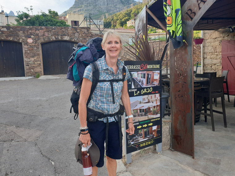
Sunday 23rd June 2019 walk from Calvi 0m to Calenzana 255m Stage 0
When we booked the trip, Corsica Aventure recommended starting on a Sunday. Maybe this is because Friday or Saturday starts are more popular, making the refuges busier. Once in Corsica we realised that the downside of this is that there is little public transport on a Sunday.
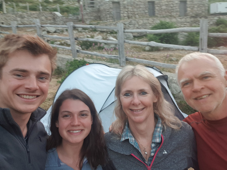
We had been staying in a bungalow in Calvi, so packed and left. At this point we did think our rucksacks seemed heavier and larger than normal for a long distance hike. We realised that there is no public transport to Calenzana-where the GR20 starts, on a Sunday, other days there is a daily bus, which we had seen hikers catching. Taxis are available, but on a Sunday increase their fares, by another half, making the fare for the 11km €45. However, we decided to walk as a warm up!!. We dipped our boots in the ocean, and headed up the road. Maybe this was not the best plan. After about an hour we were regretting this decision, it was very hot, the country roads were much busier than we imagined with the traffic going past us very fast. After about an hour's walking, we reached the sanctuary of a Spar supermarket, (nothing like an English Spar, more like being in Waitrose) which stocks food, sun tan lotion, etc and which had a cafe and toilet. https://www.supermarche-calvi.com/ At this point we remembered we had not been to the cash point in Calvi before leaving-mistake. Unfortunately there was not one here. We continued walking, sitting in the frequent bus shelters to rest and keep out of the sun. Quite a few taxis passed presumably hikers taking the easy option (or sensible) to Calenzana. Later we met walkers who had just flagged down cars, and got a lift. One walker tried to follow a path from the trainstation of Dolce-Vita GR20, getting lost for about an hour, then realised that the path no longer exists.
After nearly three hours of walking in the heat, we arrived and checked in at Gite D'Etape de Calenzana at 3.30pm. An envelope from Corsican Aventure was waiting for us containing A4 colour maps of the trip, a small brochure, and an ING map of the route. We met a young French man who had given up after 2 days due to a bad knee, he said a major heat wave was coming in, a shame and a warning. https://gr20-infos.com/hebergements/gite-municipal-de-calenzana/
There were 2 pairs of bunk beds in our room with an en-suite bathroom, and charging points were available in the room and in the kitchen. We shared with a lady who had just walked from south to north in 15 days. She looked worn out, and said there were just a few patches of snow, and we did not need crampons. We were concerned as we had too much kit. At this point Dave got rid of an old softshell jacket and merino wool top. Outside the post office we very fortunately found a cash machine. At this point we did not realise it was the last one before arriving in Porto- Vecchio, in 2 weeks time.
Dinner had been booked for us at the GR20 bar at 7pm, we ate salad, pasta, and ice cream, which was very filling. Strangely there were not many people around. We booked breakfast for 6.30am, in hindsight we should have booked 6am. Calenzana is a nice village, pleasant to walk round with various restaurants and a hotel. https://www.tripadvisor.co.uk/Restaurant_Review-g1073586-d2262279-Reviews-Bar_restaurant_le_GR_20-Calenzana_Haute_Corse_Corsica.html
Monday 24th June Calenzana 255m to Refuge Ortu Di U Piobbu 1560m Stage 1Baptism of fire
Many people were up and leaving by 5am when it was still dark. When we rose at 5.30am the whole place was a hive of activity with many walkers using the kitchen facilities, and tents being dismantled etc. We went to the GR20 bar, and together with others waited for it to open. We finally left at 7.10am after a lovely breakfast and carrying our picnic lunch provided by the restaurant. We were keen to get on our way as by this time many walkers seemed to have left-a message for the trip to come.
The path is well marked by red and white paint along the way. As we wended our way uphill we had fantastic views back over Calvi, and the places we had walked to in the previous week. We reached a spring 2 hours after leaving so replenished our water bottles. To be on the safe side we always added a chlorine tablet, but we met others who did not, and they had no ill-effects.
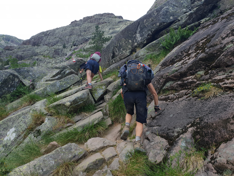
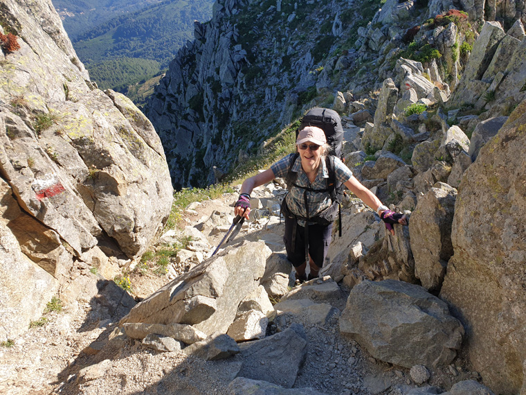
After 4 hours of walking we reached the top of a steep zig zag slope at Bocce Saltu at 1250m, meeting new friends along the way. Stopping for lunch in the shade, with great views to the sea. Continuing on we discovered the first of many chains on the trip which are found on steep slopes, and I was unsure how best to make the most of these, whether to just hold them and abseil down, or be more cautious holding onto the rocks at all times, and the chain. Later when we had seen the chain which had become detached from the rock, we learnt to always hold onto the rock and the chain. We finally arrived at Refuge Ortu Di U Piobbu, at 1560m at 3.30pm, after nearly 9 hours of walking. In some refuges you were assigned a tent, but in the majority like this one, choose a tent first then go to book in. We thought this was a tough hot day, especially carrying the packs (not compared to what was to come). The refuge itself had burnt down in May(a criminal matter), but tents, 4 Eco toilets, separate cold showers for men and ladies with a wash basin and mirror are available (again nice compared to what was to come). The water source is 100m beyond the refuge, we filled up the night before leaving. However, we and others awarded the refuge the worst food of the trip. A 3 course dinner for €19 at 6pm is provided, the first course was vegetable stock with 3 small potatoes and a piece of carrot, the main course was vegetable stock with some kidney beans in, dessert was a choice of crème brulee, or canned fruit salad. I realise that the refuges have to be supplied by helicopter, but beer, coke, chocolate etc was always for sale everywhere we went. I was still hungry after dinner. I have since received feedback from Corsica Aventure, who received other complaints - they have raised the issues with the park, and have been assured that it was a temporary blip. The only good things about dinner were that we met nice friendly people of all nationalities, including a party of ten from England who were on a guided tour, and we all had fantastic views down the valley.
In fairness at Ortu, the refuge required emergency reconstruction following the fire and a replacement guardien to even accept walkers, (the only alternative being in Bonifatu, a detour of 3 hours walking time in/then out). So we were lucky really.
http://www.le-gr20.fr/en/pages/refuges/refuge-ortu-di-u-piobbiu.html.
Distance 12km
Total Ascent 1550m
Total Descent 235m
Suggested walking time without breaks - 6 hrs
Our actual walking time with breaks/eating - 8 hrs 47 mins
Tuesday 25th June Refuge d'Ortu Di U Piobbu 1560m to Refuge de Carozzu 1270m Stage 2 Welcome to the real GR20
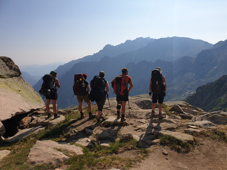
We were up early in anticipation of today's trek. The first 3 days are described as being amongst the hardest of the trip. Breakfast was at our allotted time of 6am, the walking party having eaten at 5am. Again the food was very poor, with bread, crackers and jam, €9 being charged. There was nowhere near enough calories/protein/or carbohydrates provided for the day's onslaught. We left straight after eating, the path went steeply uphill, it took us 3 hours to reach the ridge. We observed fantastic scenery stretching out in all directions whilst eating part of lunch- rice with some vegetables in. Most other walkers had passed us, but we chatted to many people coming the other way.
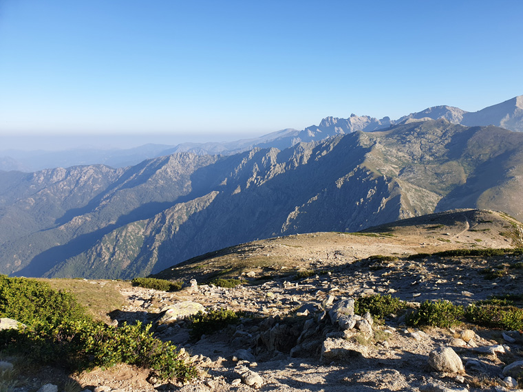
The path continues over very tricky terrain, stretches of rock climbing are involved, making it very slow going, but with exceptional vistas from the col at 1898m. Eventually the refuge comes into view. Unfortunately this was way below us in the valley. Lots of scree slopes, a tricky descent and very hot sunshine with no shade, made this day very tough, taking us 10 hours altogether. We were learning fast about the necessity of leaving early, both in order to try to avoid the afternoon sun, and the walking times given by Corsica Aventure and Paddy Dillon's book, were hours less than the times the walks were actually taking us.
On arriving at Refuge de Carozzu 1270m we found a tent, the dormitories are shut due to bed bugs. I was exhausted and lay in the tent for an hour before queuing for the mixed cold showers. Here there are 4 eco toilets, 3 mixed cold showers, and 2 sinks, and also a separate area with more sinks and clean water. Also a useful small shop. We were on 3rd sitting of dinner at 7.30pm, with lovely soup, plenty of pasta, and large slices of chocolate cake-so different from the previous evening's dinner, and again a great view down the valley. Our new friends all found it a tough 2 days, some wondering whether to continue.
For the first two days there are easier alternative routes- with walks through the valley, however we did not meet anyone who had taken them, it seems everyone is here for the challenge.
http://www.le-gr20.fr/en/pages/refuges/refuge-carrozzu.html
Distance 8km
Total Ascent 750m
Total descent 1050m
Suggested walking time without breaks - 7hrs
Our actual walking time with breaks/eating - 10 hrs 36 mins
Wednesday 26th June Refuge de Carozzu 1270m to Hotel Le Chalet Asco 1442m Stage 3 Slabs/Chains and wires
The campsite was a hive of activity when we woke at 5am. The food here was well organised with breakfast being left out with walkers' names on. Leaving at 6.15am we crossed a small Himalayan type bridge, with a sign saying only 2 people at a time to cross. Today cautious walkers were crossing singly. An exciting part of the walk then commences, the Spasimata slabs with many chains to hold onto. This was a tricky section, and gave us a taste of what was to come later. In parts of it, if you missed your step, it was a long drop into the valley! Part of the chain had come away from the rock, which does not inspire confidence. Great care needs to be taken, I would not like to even attempt this route (or most parts) in wet weather, and there does not seem to be an alternative. We fortunately were in the shade for the first 2 hours of this walk, eventually reaching Lac de la Muvrella 1860m at 9.15am. We ate part of our picnic lunch of tasty couscous, apple, bread and juice halfway up the next steep slope, again with fantastic views back to Calvi.
Up to the top of the second col 2003m at 11.30am, with a lovely view down the valley to our destination Haut Asco-hard to imagine this is a ski station in the winter months. Even though it did not look far, it took us nearly 3 hours to reach it. The terrain again consists of very rocky ground, steep scree slopes, with rocks and boulders to be climbed over. We were also trying to keep out of the very hot sun, Europe being hit with a heat wave at this time.
Eventually we arrived at Hotel Le Chalet, 1422m which I would really recommend. Arriving in the early afternoon gave us the chance to relax and complete our laundry - which cost €8 for a wash and dry. The hotel also has dormitory rooms in the basement. It offers a delicious 4 course meal for € 20, starting from 6.30pm. We arrived at this time, but realised we should have booked the time in advance as it was very busy with residents and non-residents. Dinner consisted of vegetable soup, chicken, potatoes and vegetables, cheese, and chocolate mousse. We wished we could have such great food every night. In the bar there is an excellent shop selling food, fruit, wine, walking sticks, souvenirs etc. We booked breakfast for when the restaurant opens at 5.30 am and ordered a picnic lunch. The hotel is on a road with 2 buses a day or a taxi service, some walkers decide to leave here, or spend an extra night in the hotel.
http://www.hotel-lechalet-asco.com/hotel-asco-corse/
By this point we had realised that we had brought too much kit, making the rucksacks bigger and heavier than we wanted. At home we had not quite realised how hot it would be, necessitating carrying 3 litres of water each. Also the packed lunch supplied by the refuges, was sometimes fairly cumbersome. We had been told to bring a plastic lunch box of 0.8 litres, but when filled with lentils, pasta or chick peas, this does add more weight, with bread sometimes as well, also using space. The weather was a lot warmer than it usually is in June, we had brought warm hat/gloves crampons etc, as there is sometimes snow on the path in June. Talking to many walkers who were walking the path in the opposite direction we found there was no snow. We analysed all our kit, and ruthlessly gave some of it in at the hotel, hopefully they can give it to walkers in the future. I got rid of an old coat, winter hats, gloves, ponchos (as maybe impractical on the trip anyway), even the small French phrase book. We kept an umbrella, (always useful in sun or rain) waterproof coats, and one winter hat - just in case. By 6am every morning we were dressed in shorts and T-shirts, only wearing a fleece occasionally at dinner time. We did not need the 4 season sleeping bags we had brought for the trip, but as these were rather expensive, we kept them! A silk sleeping bag and lightweight summer sleeping bag would have been fine. But another time it may have been cold and raining/snowing.
Distance 6km
Total Ascent 860m
Total descent 710m
Suggested walking time without breaks - 5hrs 30 mins
Our actual walking time with breaks/eating - 8 hrs 8 mins
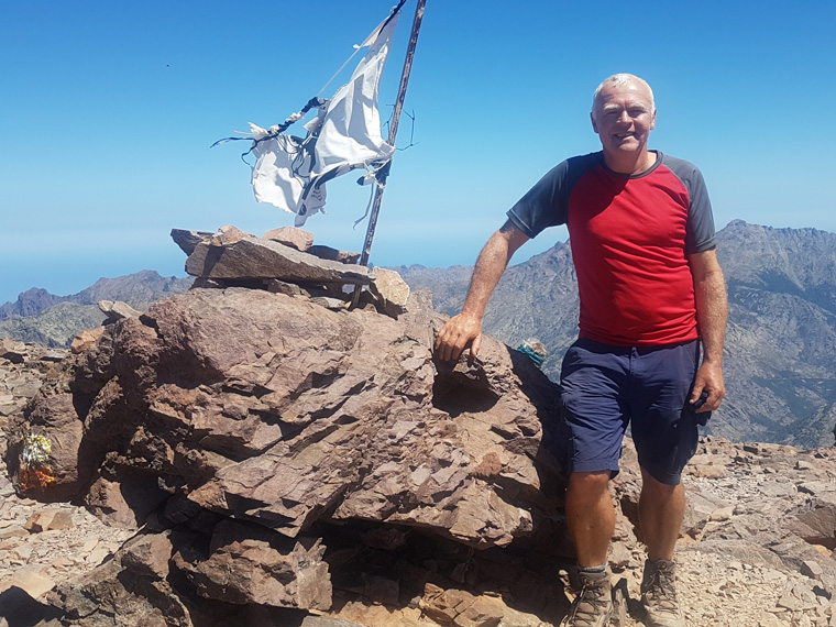
Thursday 27th June Hotel Le Chalet Asco 1442m to Auberge U Vallone 1440m Stage 4 Toughest day on Europe's toughest hike.
The path now taken was originally the alternative variant of the GR20, but since a huge rock fall in June 2015 , which caused the deaths of 7 walkers, the Cirque de la Solitude is no longer the main route, and has been indefinitely closed. The GR20 walking trail was diverted, a whole new section was way marked and equipped. The walk is now longer, more physical and a lot higher than the original itinerary which means snow is present for longer, and the weather maybe worse. It is recommended not to tackle this stage in poor visibility or poor weather, and to start out early. Some local guides and many walkers would like to see the Cirque de la Solitude re-opened, though chains, and ladders would need to be rebooted, and slopes tested for further rock falls.
Read more at http://www.le-gr20.fr/en/blog/14th-june-2018-the-opening-of-the-cirque-of-solitude.html#Bsy8oGPOEhaULqUA.99
We had ordered breakfast for 5.30 am, but we could see many walkers leaving at 5am, as the path was visible from our room. I think this was unfortunately the last sit-down breakfast of the our trip, as it is necessary to start walking as soon as it is light at 5am. Leaving at 6am, with a huge picnic for lunch prepared for us by the hotel, fortunately we now had more space to carry it. For the first time, jumper and raincoat were in the rucksack, instead of dangling from it. The walk starts with a nice gentle stroll through the pine forest. We were surrounded by high mountain peaks, all looking fantastic in the early morning sun.
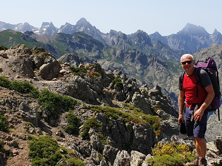
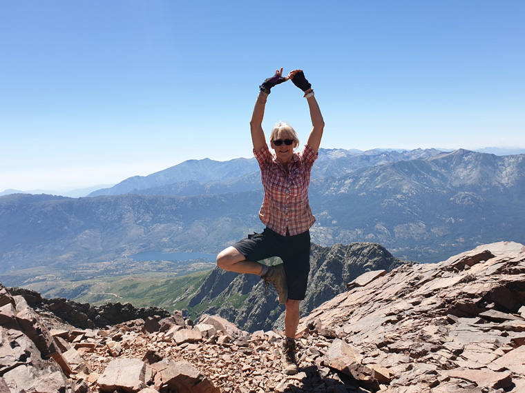
However, the walk then takes on a different perspective - a steep climb over many slabs with the use of chains. I did feel myself actually enjoying the challenge of this-if only for a couple of hours!!! After about 3 hours from the hotel there is a water source 200m off to the left of the path. However today's ascent never seemed to end, taking us 5hrs 30 mins from leaving the Hotel to reach the Pointe Des Eboulis the highest point of the GR20 at 2607m, again tough terrain of scree and rock climbing. If feeling very energetic there is a path from here to the top of Corsica's highest mountain - Monte Cinto 2706m, this was definitely not for us, and we did not meet anyone doing it.
We ate our lunch here on top of the ridge, again with tremendous views. Leaving at 12pm, we followed the path around the col to Bocca Crucetta, taking an hour.
At this point Refuge de Tighjettu can be seen in the valley, we began descending the scree slope, thinking this stretch may not take that long. How mistaken were we!!! Due to the terrain, the walking times turn out to be similar for ascending and descending. We had a very tough afternoon negotiating our way down this slope, again with much clambering involved, and made worse by the heat. I was looking forward to buying cold drinks at Refuge de Tighjettu, however, when we got closer we realised that the refuge is actually slightly uphill, not on the path. My need for a cold drink was not that great. From there we followed the river down beneath some trees for a further hour to tonight's destination of Auberge U Vallone. Each day we always did seem to be the last to arrive, this time at 5.30pm. However, the numbers of walkers starting on day 1 seemed to have fallen away, with many bailing out, spending an extra night in Asco or connecting with the transport found in Asco to other parts of the island. So we were quite proud of ourselves to still be there at all.
I have never been happier to arrive in a tent!. Auberge U Vallone is a very small quiet site, most people staying in Refuge de Tighjettu, there is a river nearby where some walkers bathed- I was far too tired. There are 3 cold showers, 2 toilets, and 2 sinks and a mirror.
We were served a delicious dinner consisting of charcuterie with bread, meat pasta and fruit at 6.30pm by Marvin who could not have been friendlier. We ate with our English friends Andy and Marie and a German couple who were walking the GR20 for the third time, having completed one time in thick snow, without being able to see the marker signs. We thought they were quite insane. Make sure you sit outside at the back of the refuge with lovely views of pine trees and valley.
http://www.le-gr20.fr/en/pages/refuges/vallone.html
Distance 9km
Total ascent 1250m
Total descent 1230m
Suggested walking time without breaks - 8hrs
Our actual walking time with breaks/eating - 11hrs 32 mins
Friday 28th June Auberge U Vallone 1440m to Castel di Vergio 1404m Stage 5 Heat and helicopter rescue
Having ordered and collected our breakfast of a flask of coffee, bread, cheese, ham and apple yogurt the night before, we sat outside at 5.30am (breakfast being served at 6.30am) eating it with our new friends. Leaving at 6.15am the walk is beautiful under trees with some views, after 2 hours we stopped at a very pretty waterfall. The norm now every time we saw water was to put our sunhats fully in, wetting them, then wearing them, as a measure to try to cool down at least momentarily. At this time the path was very quiet, as the majority of this day’s walkers were still behind us, having stayed at Refuge de Tighjettu. It was a steep climb using some chains to the top of the col at 10am. We followed a lovely path (the first one of the trip) to Refuge de Ciottulu di L Mori, at 10.45am where I ate a delicious omelette and bread, and replenished our water. We had a picnic lunch with us from the previous refuge of lentils with tomato and cheese, and juice- but personally lentils are not quite my food of choice. We had given one portion of the lentils to our friends who loved them.
This would be a lovely place to stay if wanting a shorter day, especially after the previous tough day, and/or coming over from Refuge de Tighjettu. There is a friendly guardien, nice tents, great views, but being the highest refuge on the GR20 at 1991m - it may get cold.
http://www.le-gr20.fr/en/pages/ciottulu-refuge.html
There seemed to be a path straight down but we continued around the col, the path and scenery reminding us of the English Lake District. But of course it did not remain easy for long! Once more we were on steep screes, but eventually were led to a path down to the river which has watering holes for bathing, it did look fabulous, but we continued, wishing to avoid the hot sun. We arrived at 2pm at Bergerie De Radule 1370m, and had been looking forward to refreshments, however the bergerie looked like it had not yet opened for the season, so we ate our lentils in the shade. We continued the walk now seeming endless through undulating forest arriving at the hotel at 3.30pm. So happy to arrive, and be out of the sun.
On arriving we met Glen in the bar whom we had seen on and off for a few days. Glen was part of a guided group of ten English walkers who had booked the whole GR20 independently of each other. After day 2 Glen had sunstroke so had been advised by the guide not to join them again for 5 days. On this day Glen had received a message from his wife saying that another of the guided group had sun stroke and had been helicoptered off the mountain to hospital. We were surprised as of the first 5 days walk, this was by far the easiest. However, I think that the walking/terrain and at times lack of good food does catch up. It was interesting watching the guided party as they went faster than us, with fewer breaks, but the breaks they took were for longer. We also heard of a French lady whom we had seen struggling down the previous day with her husband - he was helping her as well as carrying both rucksacks, she had also been helicoptered off. A lesson to all we felt. So the guided group of ten were now down to 8.
We had a lovely room with a balcony with chairs and a table on, we could watch fellow walkers arriving along the road. This is also a ski station with button lifts opposite. As we were leaving early we checked to see where the path continued, lucky we did as it is slightly confusing. There is a shop in the main bar with some food, pharmacy products etc, buy before dinner though, as this bar was shut later. Next door to the hotel is a refuge, some walkers stayed there and ate dinner in our hotel. The hotel being on a road, has bus/taxi connections with parts of the island, and apparently a pack-carrying donkey can be used for the next stage.
Possibly the best food of the trip was served in the restaurant at 7pm, a delicious 3 course meal €27 of Corsican soup, steak, and a dessert. As it was Friday night we had red wine, reserve a table on arrival at the hotel.
https://www.hotel-castel-vergio.com/-1-en.html
Distance 15km
Total Ascent 850m
Total descent 870m
Suggested walking time without breaks - 6hrs
Our actual walking time with breaks/eating - 9hrs 15mins
Saturday 29th June Castel di Vergio 1404m to Refuge de Manganu 1600m Stage 6 Glacial Lake
Even though this was one of the easiest days, we left the hotel at 6am to make the most of the lovely cool morning before the sun came up. We followed a great path through the trees signed for Lac De Nino1743m, eating our breakfast of apples, ham, cheese and bread in the shade. After an hour of walking the path then turns sharply right, going uphill to a beautiful small religious shrine, arriving at 7.40am. Turning left it took us a further 2 hours to reach col St Pierre 1883m, with fantastic views down to the lake - which is actually frozen for 6 months of the year. Today it was pretty, but looking like it was drying out, and not where you would swim. We ate some lunch consisting of pasta with tomato, sweet corn, cheese and carrot, overlooking the lake. Very tasty and we wished there was more.
The path down from here splits around the lake, we chose the original path to the right, as it passed a water source on the right handside. We were told Bergerie De Inzecche at the far end of the lake was shut when we were there. The path continues following a beautiful river. We stopped for a drink at Bergeries De Vaccaghja, more rustic than other places, there is a campsite, but no toilet or showers, a small shop, food and drink are served, but with no menu. We went for the simple life and ordered coke. http://www.le-gr20.fr/en/pages/refuges/vaccaghja.html
From here we were happy to see across the valley tonight's destination of Refuge de Manganu. It took a further 45 minutes of striding out (a pleasant change) until we arrived, nice and early at 1.30pm. We received one of the best welcomes of the trip by the guardien Alain -who instantly knew everyone's names, and showed us to our tent. I was hungry so ordered omelette, bread and coffee. On site were phone charging,4 eco toilets, a treat of 3 hot showers - buy a token for €2 gives 6 minutes of hot water, one cold shower, 2 sinks, no mirror, and a washing line, There are lots of tents- with cows wandering through, some beds packed tightly in the refuge, and a river nearby where some swam. Thunder threatened all afternoon, but fortunately the expected storm never arrived, our washing out on the line by now.
We ate charcuterie, pasta, bread and mousse for dinner on the terrace overlooking the valley with an American couple who had flown from Montana to Corsica especially to walk the GR20 to celebrate their friends' birthday. We were amazed at this given the quantity of walking in the USA. Great food, lovely people, and fantastic views.
http://www.le-gr20.fr/en/pages/refuges/manganu-refuge.html
Distance 17km
Total Ascent 670m
Total descent 475m
Suggested walking time without breaks - 6hrs
Our actual walking time with breaks/eating - 7hrs 30mins
Sunday 30th June Refuge de Manganu 1600m to Refuge de Petra Piana 1842m Stage 7 Best views ever.
After yesterday's easier day, today looked harder so another early start, up at 5am. Breakfast of bread, jam and coffee was eaten with fellow walkers on the terrace (again left out with our name on by the guardien). Leaving at 6am we crossed the pretty river then followed it upwards, after about an hour we replenished our water bottles from a fountain to the left of the path. The path then follows the now accustomed tradition of rising steeply until we reached the top of the col-Bocca a e Porte 2225m at 9.45am, after stopping for a sandwich along the way. Quite a crowd had gathered here - well crowded for the GR20, with at least 10 people. It is inadvisable to take this path in adverse weather conditions as it is high, steep, and with the possibility of snow still lying here, we were very fortunate as there was no snow on the path and we had clear weather.
The views at this point were again tremendous as we were really back in the mountains. Two small lakes glistened below. We followed the col round, with huge boulders, rocky slabs, till we reached a big downwards gully with chains. To one side are steep rocks without chains that some walkers took, in hindsight I think that this would have been easier than trying to climb down chains. A hole in the rock is then reached: in order to fit through the gap walkers remove their rucksack and throw it down to friends below.
Whilst walking along the ridge there are amazing views to the village of Cortes and all around, reaching Bocca Soglia at 11am. The path eventually turns left off the ridge, crossing more boulder fields, and an uphill section (again steep with scrambling and stony zigzags to Bocca Muzzella 2206m. We stopped to eat our delicious lunch of tuna pasta, fruit, and bread. We had a chat with two guys from Belgium who warned us about the poor sanitary conditions to come.
Two cols later at 1.15pm we were rewarded with our first view down towards the next valley. Again the terrain down was tough, and we arrived at Refuge de Manganu at 2.45pm after another fairly long day, but at least it was cloudy in the afternoon and not as hot. The walking party we had met on previous days, were walking 2 stages today to L'Onda, which was a shame as we did not catch up with them again, other new friends were staying here though.
We had been warned about the toilets. There were 2 cold showers, and 2 squat toilets, and one sink with no mirror for at least 60 people. Not the best, but worse was to come!! There is a shop selling a good variety of food. We chose our tent, again with great views down the valley and over the mountains. There were 2 sittings for dinner, ours at 6.30pm on a long table with about 30 people. The guardien made a big speech about the food, to our detriment we did not understand it! A bowl of lentils, with 2 pieces of very fatty bacon each, a big piece of cheese, and half a tinned peach were presented, very odd.
http://www.le-gr20.fr/en/pages/refuges/petra-piana-refuge.html
Distance 10km
Total Ascent 980m
Total descent 740m
Suggested walking time without breaks - 7hrs
Our actual walking time with breaks/eating - 8hrs 45mins
Monday 1st July Refuge de Petra Piana 1842m to Refuge de L'Onda 1431m Stage 8 Easy hiking, followed by river swim
This refuge is high, and the only place where there was mountain dew on the grass in the morning, so don't leave anything outside the tent. This was definitely the easiest day of the trip. We had an unaccustomed late start, up at 6am, leaving at 6.40am, again carrying breakfast and lunch. Today there was a choice of the high route along the ridge or a low level route. We chose the low level, partially as it is the real GR route, and because we felt it would make a pleasant change from clambering round on ridges! Many took the high level.
A gentle downhill walk with beautiful views down the valley. On reaching some deserted shepherds' cabins at 7.20am we sat in the shade and ate our breakfast. For a change a lot was provided with bread, sausage, jams, orange biscuits etc. Very nice especially after the strange dinner on the previous night.
After 3 hours of walking we arrived at the Bergerie de Tolla,1000m, which was one of the few bergeries we found open on the walk. Our new friends Andy and Marie were there already, we ordered vegetable tart, bread and coffee and for a change had the time to sit and enjoy relaxing. By now I had learnt where ever we saw food to buy it, as you never knew what was to come, saving the rest of our packed lunch for later.
Continuing for a further 15minutes, there is a bridge over the river, with swimming holes. We took advantage of the short day today, and had time to swim, and relax on the rocks, very beautiful.
Eventually we left following the path uphill 500m through the forest, be careful not to lose the red and white stripes, arriving at the Refuge De L'Onda early for a change at 2pm. We met fellow walkers who had followed the top ridge route, checked in at the site and were following the path down to swim in the river. They obviously have more energy than me.
This site is in a fantastic location, in a bowl surrounded by high mountains. Many walkers steadily arrived over the afternoon, the majority coming from the opposite direction than us, from a quiet start eventually there were at least 80 tents here. There is a small shop with a better choice than usual-credit cards can be used if spending at least €15, the facility to pay for phone to be charged, 2 squat toilets, 2 warm showers (well maybe warm as it was early in the day), and 2 sinks. We really enjoyed this short day spending the spare time sitting in the sun, chilling and reading. The camp was enclosed by wooden fences, good thing as it was surrounded by goats, horses, sheep etc. Dinner was at 6.30pm, served by the grumpy guardien and a small child. His wife had spent all afternoon cooking- vegetable soup, brocciu spinach lasagne-of which a large portion was served, followed by cheese, bread and chocolate mousse. Delicious and full for a change.
http://www.le-gr20.fr/en/pages/refuges/onda-refuge.html
Distance 11km
Total Ascent 500m
Total descent 910m
Suggested walking time without breaks - 5hrs
Our actual walking time with breaks/eating/swimming - 7hrs 20mins
Tuesday 2nd July Refuge de L'Onda 1431m to Le Vizzavona Hotel 920m Stage 9 Tough last day of the Northern section, Vizzavona- most disappointing place
As breakfast was being served too late for us at 6.30am, we had ordered a packed one enabling us to leave at 5.45am. We ate en route, actually at the top of the ridge overlooking the site where WIFI was available, reaching the first col at 8.15am. The path again went steeply uphill until reaching the top of Muratello 2141m at 9.15am. We were joined by about ten new walking friends, the path turns left and goes down sharply. Again the path did not look that hard, but forever deceptive, very steep with lots of climbing. We had heard about the Cascades Des Anglais, 1092m and were looking forward with anticipation eventually reaching them at 1pm. It was a very busy area with lots of families, we called into the snack bar for drinks - no toilet, we felt the whole area was fairly disappointing really. We could not believe that so many tourists had walked up to the Cascades, it seemed too far from Vizzavona and there were nice rock pools in Vizzavona in which to swim. https://www.tripadvisor.co.uk/Attraction_Review-g1842259-d8493018-Reviews-Cascades_des_Anglais-Vivario_Haute_Corse_Corsica.html
If not wishing to go to Vizzavona, and if continuing for the south GR20, from the Cascades turn right and after 15 minutes arrive at the Hotel Monte d'Oro 1150m, giving a height advantage over staying in Vizzavona. The following day the GR20 variant is signed, re-joining the GR20 after 90 minutes. This saves 2km and 270m of ascent over the main route. In retrospect a very good idea, as there was not much in Vizzavona, plus being disappointed with our hotel and other hikers who had previously walked the GR20 were staying here. https://www.viamichelin.co.uk/web/Hotel/Vizzavona-20219-_-stk0wjz6
We saw fellow walkers leaving Vizzavona in the early afternoon heading uphill to Refuge de L'Onda and did wonder if they would make the refuge before exhaustion set in, as it was so hot, no shade and such a brutal walk. Again keen to avoid the sun, we reached Hotel La Vizzavona at 2.15pm.The hotel is a very old imposing building, we had a lovely room with a nice view. Previously when I checked online there was a laundry, however this was not working. We ended up washing all our clothes in the shower, and trying to dry them in the room. Shame as we could have washed them by hand the previous day. Vizzavona, was a much smaller place than we had imagined, 2 very small shops, one by the station, one inside the refuge - which did sell a good variety - plasters, sun tan lotion, food, fruit etc. No ATM- fortunately our cash of 300 € (between 2) did last as far as Conca, but only as accommodation and food had been paid for in advance. I wonder how many people do run out of cash, as very few places take a card.
Vizzavona marks the end of the North Stage, with a station. Some fellow walkers were finishing here in order to return to work, or having a day's rest in a hotel here prior to continuing. We did think of finishing the walk here too, every day had been tough and exhausting, but decided to continue. The south section is seen as being easier than the north. The young couple, Andy and Marie, that we had dined with most nights since day one, were also leaving here, and we were sad to see them go, as we had shared great ventures together. They joined us for a last meal together, unfortunately it was disappointing, a chicken vol-en-vent appeared, and dessert of chocolate and chestnut mousse, a set price menu of €20 We wondered what happened to the main course, what food there was was very tasty, a shame that we were all hungry afterwards. Corsica Aventure are now looking at the food here, and adding to the picnic, but in fact it is meant to be a 2 course meal.
http://www.hotel-vizzavona.com/en
Distance 11km
Total Ascent 670m
Total descent 1180m
Suggested walking time without breaks - 6hours
Our actual walking time with breaks/eating - 8hrs 30mins
Wednesday 3rd July Le Vizzavona Hotel 920m to Gite du Col de Verde 1289m Stages 10 and 11 Double stage, thunderstorm with hail and lost
Maybe because the southern section is seen as easier, Corsica Aventure with whom we had booked the trip had doubled up the next 2 stages, giving us a day of 28km, with 1210m of elevation. We had seen this plan before we left home, but we were not too daunted. Hmm. After a bad night's sleep, we were up at 5am leaving at 5.40am. We had asked the previous night for a packed breakfast but the manager had refused (the only one of the trip to refuse), saying breakfast was at 6.30am - too late for us, with such a long day. He made us packed lunch of an apple, cheese and ham sandwich and a small carton of juice. We were disappointed with this hotel, and would not recommend staying here, overall there was a lack of effort especially as the hotel is on a main road, so should not be a problem fixing the laundry and supplying food.
We headed off, excited to follow the signs south, reaching the top of the col - Bocca Palmento 1645m at 8.10am, having followed the path through the beautiful woods, with plenty of bird and animal life. Having had no breakfast-as too early, and hungry from the lack of dinner the previous night, we ate our lunch.
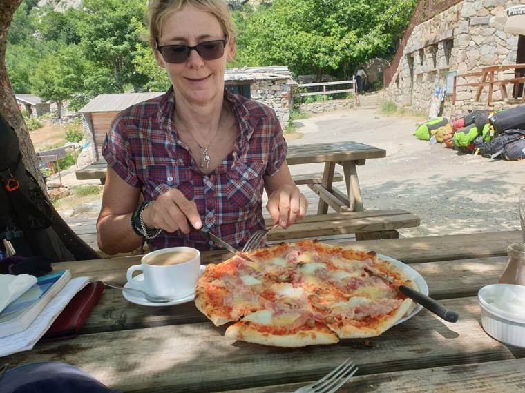
Great vistas are all around, the walk continues swinging downhill through the forest, passing the closed Bergeries D'Alzeta, then up steeply through trees. At 11.30am we crossed a road with melting tar, and continued. Walkers coming the other way said "Pizza 10 minutes", we were confused thinking we must have mis-heard them. We arrived at Capanelle refuge 1586m at 12pm. And yes we saw the menu and ate one of our nicest meals of the trip, pizza, salad and coffee. Served very quickly by a very friendly young man. http://www.le-gr20.fr/en/pages/refuges/capanelle.html
This is the end of a stage, it was a shame that we were not staying here, as then we could have had breakfast in our hotel, enjoyed the walk taking our time with great views. This was a nice refuge, with good food, tents and toilets. 16km, +1000m -335m would have still been a good achievement. Also by doubling up the stage we unfortunately had left our remaining friends behind.
However, we had to press on, leaving at 12.30pm via another beautiful path through trees by a river, so different from the first 4 days in the north. We had been warned about the thunderstorms, and I had even read up on what to do in advance. However, when the thunder and lightning began we were in the middle of a forest -at least not on top of the mountains. We sheltered under a tree, sharing our umbrella, we even kept our rucksacks on to keep our backs dry! I was so wishing that we had not got rid of the ponchos on the earlier cull of unwanted items. Maybe a tree was not the best place to be as the storm was totally overhead, very scary, with hailstones the size of a euro coin.
After at least 30 minutes of sheltering we decided that we needed to get going, and just get wet, as it was now 3.30pm. We left the forest arriving at a deserted farm, but with lots of animals sounding like they were in distress. It was as scary as the storm!!! Here we lost the path, there seemed to be red and white markers going up the hill, but as a fire had come through we could not find any more markers. In the southern section some of the painted stripes were replaced by red and white plastic nailed onto the trees, and we thought these had melted in the fire. After wasting much time we decided to turn round back to where we last saw the path, which was in a clearing- Plateau de Gialgone. We found a path with cairns - not red and white, but took it, needing to escape from all the farm animals, including a herd of cows on our path. Eventually we came to the Bergeries des Pozzi, and a very helpful farmer, with some English told us the way that we needed to follow. Later we rejoined the GR20 at Col de La Flasca, normally we would have stopped to look at the waterfalls, but needed to keep going. We were very happy just to see the correct signs, I had had visions of having to camp out in the forest.
We followed the path, then forest track, past a car park, down to Refuge de Verde, arriving at 7.30pm. There were about 60 people all sitting eating, The guardien initially ignored us, then said "we should have left earlier", in perfect English. Not what we needed to hear after a 14 hour walk. In hindsight we realised that we should have carried on walking during the storm, and had we not got lost may have arrived sooner but even so it would have been a very long day. The guardien said we were in hut 2, which was like a small summer house with 7 beds in, no tents here. We had dinner at 7.45pm with 2 Irish guys, who had also walked from our Hotel in Vizzavona starting out after breakfast, and arriving 10 minutes prior to us. They said the guardien likes everyone to arrive before 7pm in order to fit in with his time for dinner. Dinner was nice, pork chop, pasta, salad, prior to my cold shower in the dark. There are 2 toilets- both with broken wash basins, 4 cold showers and a sink - no mirror, and a small shop serving snacks. Personally a place to avoid.
http://www.gites-refuges.com/www/detail.htm?ID_HEBERGEMENT=2928
Distance 28km
Total ascent 1320m
Total descent 685m
Suggested walking time without breaks - 9 hrs 30 mins
Our actual walking time with breaks/eating - 14 hrs
Thursday 4th July Gite du Col de Verde 1289m to Refuge Usciolu1750m Stage 12 Toughest day of the Southern section, and vanishing water sources
After yesterday's 14 hour day leaving us tired, we were faced with another long day. 3 people in our room were up at 4am as they were trying to complete the whole walk in 9 days, they had started in Conca heading north. After trying to get some more sleep, we were up at 6am, and waited till 7am for breakfast.(mistake) Most people heading north had already left. Eating with the Irish guys they said they had skipped some of the days on the north section, and wanted to catch a taxi out of this place, did we want to join them? We thought for a split second, but had not come this far to give up now. We presumed we would see them on a later stage, they too had booked with Corsica Aventure, but we did not see them again. We collected our picnic lunch.
A steady walk uphill through the trees, then uphill again arriving at the col- Bocca d'Oru 1934m at 9.30am then Refuge de Prati 1820m at 9.50am. This has lovely views to the sea, a shame that no food was available - as the guardien was busy. It is a small site, tents with fantastic views, one toilet, and 2 showers, and WIFI.
A long ridge walk then ensues, with more slabs and climbing necessary, which would have been fantastic if we had not been so tired. The path fluctuates from one side of the ridge to the other, with great views to the sea, then inland. We ate our lunch of rice and bread on reaching Col de Lapardo1525m at 2.15pm, the junction of various paths. Just when we thought the hardest part of the day was behind us, the path then rises 500m on a seemingly endless path, finally we followed the zig zag path downhill to Refuge D'Usciolu at 5.30pm.
We received a lovely welcome from the guardien, he did ask where the Irish guys he was expecting were, obviously they had not cancelled or turned up. The guardien kindly charged our phone, and directed us to the best located tent. I found a shower and toilet at the bottom of the campsite. The shower door had one hinge so on entering the shower I asked the next person in the queue to place the door closed, likewise when leaving asked them to re-open it. The previous lady had unfortunately been hit on the head by the door falling on her. I later found another shower- complete with mould and no door but a shower curtain and toilet at the top of the site. But never found a wash basin, let alone a mirror. There was a water source near our tent where I could wash my hands. In my opinion this site has the worse sanitary conditions of the GR20, but has the best stocked shop, and one of the nicest Guardiens.
Dinner at 6.30pm, again the Guardien made a special effort for us, we had charcuterie, plenty of pasta, fruit, cheese and bread, sometimes it pays off booking with a company. We ate dinner with a German lady who had run out of water in the afternoon, either the source on the path was dry/or she had not managed to find it. She asked other people for water, but they were also running short, she did acquire a small amount. A salutary lesson in such hot weather. The shop here was just incredible with so much food and even walking boots etc, apparently the guardien goes down the hill on his horse to collect supplies.
Bit of a drama here when the raw sewage from the toilet at the top of the site leaked and ran down the hill through the campsite. Some people moved their tents. I did feel sorry for the man at the one water source trying to wash the raw sewage off his rucksack!! However, they are in the process of building a new eco toilet block here, hopefully it will be finished soon! It certainly needs to be. We have since been informed that the new toilet block with shower is now open.
http://www.le-gr20.fr/en/pages/refuges/usciolu-refuge.html
Distance 16km
Total ascent 1290m
Total descent 830m
Suggested walking time without breaks - 8hrs
Our actual walking time with breaks/eating - 10 hrs
Friday 5th July Refuge Usciolu 1750m to Bergeries de Croci 1550m Stage 13 Best welcome, at the best refuge.
After another sleepless night we awoke at 5am to the accustomed sound of many boots going by. We ate our breakfast of bread, sausage and cheese at 6am, having ordered it the night before. No chance of a lie in here, the builders for the new toilet block started work at 6am. We were virtually the last to leave at 6.45am. The majority of people on the south section were heading north, unlike ourselves. Uphill again, with lovely views back over the site and the sea, turning left to follow the ridge, there are some fairly tricky sections, with the path flipping from one side of the ridge to the other.
When the ridge ends, drop down along a nice path, eventually through trees, to a clearing with various paths. The scenery changes at this point leaving the mountains behind, with nice paths. The water source was not flowing, fortunately we had taken enough water with us. We forded the river, continuing besides it and ate an early lunch of bread with canned tuna on the banks of the river. The uphill path is signed, but there is an alternative path that follows the river up to Refuge de Matalza, which we took, arriving at 12.30pm but were not sure if that was any quicker than the real path.
Refuge de Matalza1410m is very small with a few tents, but a nice restaurant and toilet. I ordered a lovely vegetable tart, coffee and coke.
https://gr20-infos.com/refuges/matalza/
The path continues through trees, then again along a nice path. We were very pleased to arrive at our destination of Bergerie de Crocce at 2pm in order to escape the heat of the strong sun, and have a rest. Also it was one of the best welcomes we have had- by Ludo. The tents were nicely spaced out with great views, 3 free hot showers, 3 toilets, for a change all with locks, sinks, a mirror and a washing line too, no WIFI. Perfect, a lovely afternoon relaxing after doing the washing. Later our phones were charged for €1 each.
A fantastic dinner was served at 7pm, one of the best on the walk. Charcuterie, bread, a massive portion of meat and vegetable lasagne, cheese with pickle, followed by fruit. For a change we were the only English speakers, joined by some French men going our way and a French tour party heading north. Obviously the refuge being near a road does help the guardien purchase food. But this overnight stay was definitely the best one, apart from the first 2 hotels. To be recommended.
http://www.le-gr20.fr/en/pages/refuges/croci.html
Distance 13km
Total ascent 360m
Total descent 660m
Suggested walking time without breaks - 5 hrs 15mins
Our actual walking time with breaks/eating - 7hrs 32mins
Saturday 6th July Bergeries de Croci 1550m to Auberge du col de Bavella 1218m Stage 14/15 Double stage, seemingly endless in the heat, great gite
Sadly this was another day which was a double stage. We were up at 4.50am, a breakfast of sausage, cheese, and bread with hot drinks had been left out in the restaurant. We collected our lunch of chick peas with tomatoes and onion, and a huge loaf of bread. Leaving at 5.50am the first hour passed quickly with 3km walked, the scenery looking like Dartmoor. We then spent another hour climbing uphill to arrive at the top of the Alcudini Ridge at 2025m, with perfect views all round. Fantastic views back to the mountains we had crossed on previous days. We met a French walker who apologised for the very poor sanitary conditions at the refuges along the walk, and said he was ashamed of his country in this respect. I could only agree. Downwards the terrain stopped looking like Dartmoor. It reverted to typical Corsica with scree, boulders and clambering involved. We and others lost the path on this slope, fortunately we were helped by locating walkers coming up the path. After 500m of tricky descent taking us 2 hours we arrived at Refuge d'Asinau 1530m. This refuge has been completely rebuilt, together with lots of tents since a fire destroyed it in 2016. This is the only section of the walk where we achieved the same timings as given in our brochure, every other section had taken us a lot longer.
On arrival we ordered a coke and coffee, with lovely views down the valley. I would have eaten omelette but there are no eggs, there was sausage and cheese on the menu (which we had eaten for breakfast) but not a lot else, so we had our drinks and left. We had thought we would have some food at the Bergeries D'Asinau, which has rooms and food, but did not realise till it was too late that it was off the path below the refuge. Oh well we had lots of chick peas for our packed lunch to eat!! (not my favourite).
Continuing downhill, then following the wooded river valley, the walk again was much more difficult than expected, with 380m of ascent between Berg d'Asinau and our destination. We met the postman walking up to the refuge carrying a couple of letters, and 6 sticks of bread in his bag. After a couple of hours a path steeply rises to the left, this is the Alpine Variant going over pinnacles and using chains. We continued near the river, but could not believe how long this section took. The path was rough underfoot with many boulders, a couple of 100m had been cleared but the rest was slow going, especially in the heat. We met a few tourists and families who had walked from Bavella, when we met them we imagined they had not come far!!
We continued all afternoon eventually seeing high on the other side of the valley a road which we were aiming for. The alpine path rejoins shortly before we eventually arrived at the car park on the road, turning left here, and after another 10 minutes arrived at tonight's sanctuary of the Auberge of Bavella, at 5.40pm, after nearly 12 hours of walking. I was worn out, and could not have managed another step, and at this point looking forward to the whole walk finishing. The first 6 hours of the walk were great, the next 6 hours just a toil - so much for the double stage, which as I say was not our choice - see advice later.
We received a lovely welcome at the Auberge, and were shown to a 6 bed room with an en-suite bathroom. The other occupants had not yet arrived, so we chose our bunks in the corner, charged our phones, and showered. We ate a delicious and nutritious dinner outside in the court yard at 7pm, consisting of a huge pot of corsican soup, pork with potatoes and crème caramel. The other occupants arrived after we were in bed, and as we were up early in the morning we did not even see them- strange. If all the accommodation and food was as great as this life would be superb. http://www.auberge-bavella.com/
Distance 16km
Total ascent 1110m
Total descent 1310m
Suggested walking time without breaks - 9hrs 30mins
Our actual walking time with breaks/eating - 11hrs 45mins
Sunday 7th July Auberge du col de Bavella 1218m to Conca 250m Stage 16 Last day, not easy, but so happy to finish
So the last day, we were up at 5am and ate a nice breakfast very kindly left with our names on in the fridge. The Auberge has a lovely big kitchen area where people had been cooking the night before, we had plenty of space to pack our bags without disturbing the other people in our room. A shower and toilet are also separate to the room. Leaving at 5.50am it was a lovely walk undulating through a pine forest. But we got too complacent following the road for too long, instead of turning right by a cairn and had to back track. We met a lovely group of students from an English school, undertaking the gold Duke of Edinburgh award. By this stage of our walk we felt no jealousy for walkers starting out and heading north (we were going south) only sympathy, especially in the heat of the south.
http://www.le-gr20.fr/en/pages/refuges/paliri-refuge.html
We arrived at Refuge De Piliri 1050m at 8.15am ordering coffee and chocolate. We sat with great views of mountains and ocean. The water source is before the refuge, we only found one that did not look very appetising, so did not bother. Camping is not allowed at Bavella, so this is the nearest camp site. We were hoping that the path would just roll down to Conca, but no, over the day there is still 700m of ascent, together with 1670m of descent, making it another hard day. But fortunately no high ridges, or chains , the weather had been kind to us as well- except for the heat with only one thunderstorm. Still it was tough going, the path climbing steadily, then zig zags, to reach the crest 2 hours after leaving the refuge. We met a German father and son whom we had seen over the past few days. Unfortunately the father's sole had come away from his boots, - the 2nd pair we had seen like this. They were taping them together. The path does take its toll on the body and kit.
The path heading in both directions was very quiet. We reached a ruined bergerie de Capeddu 850m at 11.30am, ate our lunch of a delicious salad, bread and apple- we only wished there had been more of it. We looked for the water source which was signposted but unfortunately it had dried up in the drought, this may be why the Bergeries are in ruins. We wished we had picked up water at the previous refuge, and had to ration our remaining water, we did see a river later but the water did not look that clean. Again never assume there will be water. For the first time Sardinia came into view beyond the narrow channel that separates the two islands.
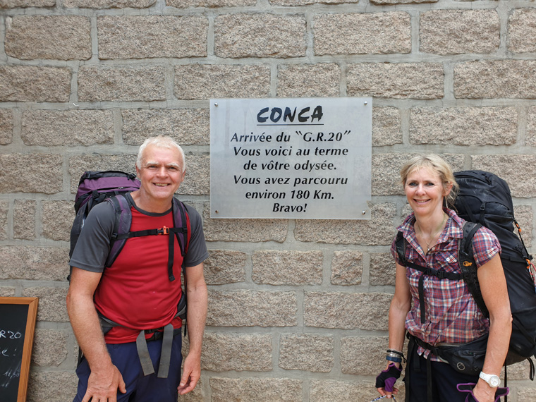
At 2pm after more uphill, we came to a narrow gap in the rocks- Bocca d'Usciolu at 587m. This is the last view back over the mountains we had spent the last 13 days crossing, instead of being sad we were really happy. We concentrated on happily seeing Conca in the distance. Following the path down it joins a tarred road, and turns left. We arrive at the Bar du GR20- appropriately named, and took many happy pictures with a sign saying, end of the path. We ordered many drinks and a sandwich, and filled in the visitors' book on the bar. We were joined by only 3 other hikers, and it was very quiet. We texted a few people to say we were so happy to have completed the walk.
As it was a Sunday no buses run here, nor did we see any taxis, I had read about a small private navette that runs from the Gite d'Etape when it is full. http://www.gite-la-tonnelle.com/le-restaurant/ We could not imagine that happening as Conca was very quiet, it was not the finish we had been expecting. In typical spirit we decided to walk 70 minutes down to the main road where our bus to Porto Vecchio was due at 6.30pm. On arrival near the bus stop, we bought food from the bakery - surprisingly open on a Sunday dinnertime, and ate it outside the Bar U Colombu, with more soft drinks to rehydrate. The bus was virtually empty when it arrived, (we could track it online), and having booked our tickets online the driver was expecting us. A family got off the bus to start walking the GR20 the next day, were we jealous?- not remotely, just felt lots of sympathy. https://www.corsicabus.org/
Distance 19km
Total Ascent 700m
Total descent 1670m
Suggested walking time without breaks - 8hrs
Our actual walking time with break/eating - 9hrs 10mins
Total measurements for our GR20 walk
Distance 191 km
Total Ascent 12860m
Total descent 12555m
Suggested walking time without breaks - 97 hours
Our actual walking time with breaks/eating - 132 hours
In hindsight these are the stages I would have chosen for the South stages, taking 7 days instead of our 5:-
Vizzavona to Capanelle
Capanelle to Refuge de Prati - avoiding the grumpy gardien at Col de Verde
Refuge de Prati to Usciolu
Usciolu to Crocce
Crocce to Berg d'Asinau
Berg d'Asinau to Col de Bavella or Refuge D'Paliri
Col de Bavella or Refuge D'Paliri to Conca
Corsica June/July 2019 Before and After walking the GR20
Sunday 16th June
We had booked Easyjet flight.6.50am Manchester to Bastia in January. We had booked all our accommodation both before and after the GR20 in advance on bookings.com, and booked the GR20 with Corsican Aventure.
We caught the bus from Bastia airport to Bastia, €9 each for the 20 minute trip. We had booked the Hotel Rivera as it is near the port, square and tourist office in the centre of Bastia. A walk round Bastia followed, it is a very pretty old town, with an old citadel, new and old ports, museums, and with many ferries departing to France and Italy. We ate pizza, salad, bread and drinks €35 for 2, by a marina north of the town which was very quiet. Many restaurants are shut on a Sunday evening.
https://hotel-riviera-bastia.hotelmix.co.uk/
Monday 17th June
After buying some breakfast at the Spar supermarket, we went for a walk, starting from Avenue Jean Zuccharelli .We used the walk described on "Corsica for hikers" website and Google maps on the phone. It was a lovely walk along quiet country roads, visiting the villages behind Bastia. 21 km, and an elevation of 600m. We stopped for a drink with fantastic views, eventually we returned to the sea at Miomo, going to the shop to buy some lunch. We had taken our swimming things so went for a dip in the beautiful turquoise ocean, however the beach/sea floor was stone and fairly slippery with algae, beach shoes would have been good. We then followed the road back to Bastia, calling into the Giant supermarket for dinner, consisting of salmon, bread, orange, and avocado, eating it on a bench in the harbour.
http://corsica.forhikers.com/hikes/bastia-north
www.google.co.uk./maps
Tuesday 18th June
We were up at 7.15am, packed and paid the bill. We had breakfast in the main square, croissant, orange, coffee and baguette € 8 each, not very good value. We walked to station, via the Spar to buy food for lunch, and bought tickets for the 9.46 train to Bastia. €16 each, cheap compared to the price of food!! The train journey is described as one of the most beautiful in the world, going through the mountains then along the coast. We were fairly excited and relaxed back in our seats enjoying the view. The train left on time, but at 11am it stopped in Ponte Leccia , the guard came down the train telling all passengers to leave the train. Not understanding the language at all, (maybe it was Corsican, it certainly did not sound like the French we had learnt at school!!). We followed the crowd and waited in the car park outside the station. After a wait of 30 minutes 2 busses arrived, most people were eager to board, putting their bags in the luggage compartment underneath the bus. We were lucky to get a seat. After 45 minutes the buses arrived at L'lle-Rousse a beautiful holiday resort. All passengers left the busses, and boarded a very crowded train. In hindsight we could have gone for a walk round L'lle-Rousse, then boarded a later train. On the train we caught we were very squashed near the toilet, and could not see any view of the sea - we were disappointed with this, but made it to Calvi only one hour late. We had a lovely welcome in English at the Grand Hotel, which has a great location near the station, harbour and citadel. Too early for check-in we put our bags in left luggage, headed to the Spar supermarket over the road to purchase lunch. We ate our delicious salad, bread and yoghurt sitting by the harbour with fantastic views over the citadel, boats, and mountains which stretch to 2000m, some still with snow on, on the far side of the bay.
After lunch we visited the tourist office which had extremely helpful English speaking staff. One of the best we have been in. Walking round the small town we visited the citadel, which is free, offering an interesting historic old centre encompassed by high walls, cobbled streets and restaurants. We purchased salad, salmon, bread, yoghurts for dinner, and again sat by the harbour with sublime views.
https://www.corsicabus.org/Train_services/Train3BiaCly.html - note the timetable differs depending on the month/school day/weekend.
https://www.grand-hotel-calvi.com/hotel-calvi-grand-hotel-1-en.html
Wednesday 19th June
We ate a delicious buffet breakfast at the Grand Hotel, with tremendous views over the bay. We could sit outside or inside, but due to the sun opted to sit inside still with great views. Then checked out, but leaving our luggage in the left luggage store.
We walked uphill to the Cathedral of Notre Dame, with fantastic views over the bay, well worth the 45 minute walk from the town. Unfortunately the church was closed. It is also possible to drive there. From here, there are two options firstly turn left just before the church and head up to a hill, with a cross on top erected by the Austrian walking club in 1972. This did look very inviting, however we turned right taking the road/path towards the lighthouse at the end of the peninsula. When reaching a small bay with beautiful turquoise water, we turned right and headed back to Calvi. 10 km and 300m of ascent.
http://corsica.forhikers.com/hikes/capu-veta
We picked up our bags walked through town and checked into our bungalow at Camping La Cle Des Champs campsite nearby. As it was our home for the next 4 nights we then visited Super U supermarket. We found most items of food more expensive than at home in the UK, including a melon for €5.30, however we bought our usual food for breakfast, cereals, toast, lunch of readymade salad, and apples, dinner of vegetables, chicken and pasta. Fortunately we had brought coffee, spices and some kitchen cleaning products from home.
https://www.calvi-cledeschamps.fr/en/
Thurs 20th June
We had thought of catching the train to L'lle Rousse and walking back, but the problems with the train getting to Calvi, and the trains being standing room only from the outset, put us off. Also the appeal of the beach was too great. On the beach chairs with umbrellas can be hired with prices starting from €12 for the back row, €15 for the middle row and €20 on the front for 2 beds with one umbrella and table for the day, together with the use of the toilets of the restaurant behind. The down side is, we got told not to eat our picnic on the chairs, which in Spain is perfectly acceptable.
The beach and sea are beautiful with perfect white sands, the sand improves about 10 minutes walk from town. The beach is just perfect, with sand, gently sloping to the sea, and surrounded by the perfect bay.
Friday 21st June
Another day on the beach followed, as it was too nice to resist, followed by a walk down the beach with the Sun setting behind the Citadel. Following the sound of a live band playing we found ourselves by the harbour, watching a live 9 piece band, with a large audience, many of whom were dancing. In other parts of the harbour other bands were also playing, maybe there was a music fiesta on. There was a lovely atmosphere, with lots of people enjoying the music. However, as it was only 9pm we felt sorry for people who were trying to dine in peace.
Saturday 22nd June
As this was our last day before our walk, we again spent it resting on the beach. We went to the laundrette, and ate our remaining food. Looking forward to the walk, meeting new people, and experiencing different scenery.
Sunday 23rd June-Saturday 6th July See GR20 walk
Sunday 7th July After walking the GR20
Following the end of the GR20, we had walked from Conca 70 minutes to the main road, catching the 6.30pm bus outside Bar U Colombu, having booked the tickets online. We had booked 3 days at the Hotel Porto-Vecchio in Porto-Vecchio. The hotel is situated between the port and the citadel. Just down the road from the hotel is a small Super u supermarket, a bit further away is a very large Casino Supermarket. The bus does not actually enter the town proper but the route ends in the port. Conveniently across the road a free electric bus goes round the town about every 15 minutes, making the citadel, port and bus station convenient. Having eaten earlier we checked into our hotel, and did not leave, exhausted from the walk.
http://www.hotel-leportovecchio.com/en/
Monday 8th July
We visited the tourist information centre in the citadel, greeted by very helpful English speaking staff. We obtained a brochure of a walk round the citadel. There are plenty of restaurants in the citadel and some more near the port, with beautiful views out over the marina, bay and distant mountains. We had not realised that at Porto-Vecchio, there is no actual beach, these being about an hour's walk-which we did not fancy, or a car trip. We really enjoyed Porto-Vecchio for the day, if we had stayed longer I would have liked a beach.
Tuesday 9th July
Bonifacio had been recommended to us, and it did not fail our expectations . We caught the bus to Bonifacio at 8.30am at a cost of €16 each, taking around 30 minutes. As the bus arrives at the port we looked at going straight out on a boat trip, fortunately we did not as a big thunderstorm started. We walked up the steps and walked round the beautiful old town, paying €3.50 to visit extra walls and a small museum, which was well worth it. We also walked down 197 steps, called the Escalier du Roi d'Aragon, which gives the town access to fresh drinking water.
Many restaurants are available for lunch, we had a superb 3 course lunch menu for €20.
In the afternoon we caught a tourist boat for an hour, around local bays and caves and viewing the town's situation on top of the cliffs. €16.50. Well worth catching. We caught the last bus back at 5.30pm - but this only runs in high summer. This was a lovely day out and Bonifacio is well worth a visit. Make sure you check the times of the buses, not wishing to be stranded there!.
Wednesday 10th July
Our final day dawned, we checked out, and caught the free bus down to the port. We were re-united by chance with walkers whom we had met on the GR20 and they had taken a couple of days longer than us to complete it, it was lovely to catch up with them. We all caught the 12pm bus - €4 each to Figari airport, 40 minutes away. We said our final goodbyes, them flying back to France, us back to Manchester via Geneva on Easyjet.
As we flew over the mountains of Corsica we reflected on the good and bad points of the trip. The fantastic views, nice hotels and friendly people met. But concluded in future we would stick to an easier walk!!!
Accommodation stayed in
https://hotel-riviera-bastia.hotelmix.co.uk/
https://www.grand-hotel-calvi.com/hotel-calvi-grand-hotel-1-en.html
https://www.calvi-cledeschamps.fr/en/
http://www.hotel-leportovecchio.com/en/
Websites used
www.skyscanner.net
www.easyjet.com
www.bookings.com
https://www.corsica-aventure.com/gb/
https://www.corsicabus.org/Train_services.html
Money saving tips at Manchester airport.
Take empty drink bottles, declare these going through security, then fill up from the drinking fountains available at all terminals. These are present at some airports -check on line https://www.aph.com/community/holidays/get-free-water-airports-beat-security-price-hikes-fill-bottles-revealed/
This time we made our own sandwiches, put them in a cool bag, taking them through security, where we had no problem with these.
Collect free newspaper, at Manchester Terminal One, The Times, The sun and The Manchester Evening News are all available, especially if there for an early flight.
Towards the gate, there are coffee machines which are only one pound a drink.
Advice to walkers
Kit to take
In addition to the normal walking kit list, these are additional suggestions:-
As all items of clothing got extremely battered on the path, I would recommend wearing old clothes. Also at times washing facilities for clothes were non-existent, contrary to what it says in the guide books. Only one sink was present at many sites, both for washing clothes and people.
Take cycling gloves to protect hands whilst climbing over rocks and moving up and down chains. I actually kept mine on all day, except when it got too hot. I find it easier to hold the walking stick, and I don't get blisters from it. Also if you fall which I did on various occasions, at least the hands are protected.
I always take a light weight umbrella on a walk, for sun and rain. However, most of the trip it was impossible to use, except at a few points to keep the sun off, and during a torrential thunder storm.
Take plenty of hand sanitizer and toilet paper. Toilet paper was only supplied at the hotels, not in the toilets at refuges, nor soap.
Wear hard wearing boots. We met two people whose soles had come off their boots and they had resorted to taping the boots back together. Not sure how long that lasted!! I cannot emphasise how difficult the terrain is, boots have to be very sturdy with soles that grip well - going over slabs of rock in wet weather. I would not undertake this walk in anything other than strong boots, but we did see some walkers in trainers. We both wore our usual Lowa boots, and noticed fellow walkers wearing them too. By being such sturdy boots, they make walking on the slabs easier with very solid soles, and have great ankle support, and are totally waterproof, especially in the small areas of water that we did have to walk through. We had no problems with feet, knees or hips, so maybe the boots do help.
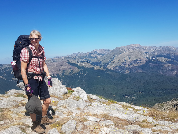
Pack light- this is difficult as all kit needs to be carried including a sleeping bag. We saw many people heading from south to north with enormous packs, given the terrain and climbing up and down chains would be very difficult with the weight/bulk of these bags. Take into account that all water - at least 3litres a day each needs to be carried, and water sources between refuges cannot be relied upon. Don't be caught out with no water. We added chlorine tablets to water we managed to collect along the way. Food for each day has to be carried too, as there are very few places to eat between refuges. So ensure there is space, and the necessary containers.
We commenced our trip on 24th June as we were informed this is the first week of the summer that snow should not be found on the highest paths. As it turned out we were in a heat wave, no snow was present on the path and it was extremely hot, especially in an afternoon as the sun beat down, generally there is no shade, as a lot of the path is above the tree line.
Work out the necessary budget in advance, (prices given later)and take plenty of money. The last cash point machine was outside the post office in Calenzana. We had mistakenly thought there would be one in Vizzavona. The refuges only take cash. The 3 hotels we stayed all took cards, fortunately for some hikers who would have run out of cash.
We took insect repellent containing deet with us, but we still seemed to get plenty of bites not sure where/what from. Bed bugs are present at some of the refuges, camping only is allowed at Refuge de Carozzu due to an infestation of bed bugs inside the dorms. We always checked the inside of the tents, and shook out the sleeping mats that were always supplied, prior to unpacking anything.
Take sun tan lotion and sun hats. We took one bottle of sun tan lotion, which we soon used, and fortunately we could buy more along the way.
Take hydration electrolyte tablets containing a salt/sugar solution. We added dioralyte to our drinking water. But would have taken tablets with us as well. Make sure you are hydrated at all times.
Take protein bars etc and stock up with snacks as necessary. We had a couple of very poor meals, the worst being at Ortu di U Piobbu, and the second worst at Refuge de Petra Piana. I felt hungry for a lot of the day, and did not feel that the necessary number of calories to complete the walk had been consumed. During the day if we happened to pass somewhere selling food (not many), we would always stop and eat. Basically we just tried to consume as much food as possible, as so much energy is being used, however we both lost weight on this walk. Also we never knew the standard of food that was to come.
As phones cannot be charged in the majority of refuges, we took a spare phone charger and a small solar panel - however this did not seem to charge very well.
We used more power as we were taking lots of pictures, videos and using the website "map my walks". Much of the route does not have mobile phone coverage.
Take first aid kit and any medical requirements with you.
Take a small lightweight gym bag or equivalent. This can be useful for taking valuables with you to the shower block/toilet or dinner, especially if travelling alone. We did not hear of anything being stolen but you never know.
Other advice
Obviously you need to be fit and have lots of experience of mountain walking, carrying kit, assessing the weather etc. Lots of upper body strength is required, for scrambling, using chains, rock climbing etc. A head for heights is an advantage or just don't look down!!
Check the weather forecast before leaving the refuge. We did not have the facility to do this, but maybe we could have asked the refuge guardien. We later learned that someone we had met had to turn round due to high winds on the ridge, and catch a taxi to the next destination. So always be prepared.
Know what to do in adverse weather conditions in the mountains. We were caught in a really bad thunderstorm, with hailstones 1cm in diameter. Fortunately we were at low level at the time, but very frightening.
Maybe fill the water bottles the night before or first thing to avoid a queue for the only tap at the refuge.
The path is well marked with red and white signs. If you have not seen any for a couple of 100ms go back and make sure you are on the right path. Apart from these, there are very few signs to actual destinations. Even when these were present, no timings or distances were shown.
We used Cicerone GR20 guide book by Paddy Dillon which seems to be the only guide book in English. We also received an abridged version of the walk and maps from Corsica Aventure, with whom we booked our trip. We found the times given in both these publications were very different from what the actual time spent on the trail was. e.g. a 6 hour walk would take maybe as long as10 hours. This is just a warning for people who look at the book and combine the stages. Obviously I realise that other walkers are fitter than us, but we found given the terrain/heat it was impossible to go any faster.
On some stages there is an alternative path. Checkout this out if you are not feeling up to the walk, or in bad weather.
We would advise against doing double stages. Our trip was booked by Corsican Aventure, and included 2 double stages. This resulted one day in us walking for a total of 14 hours arriving at 7.30pm, then having to start walking at 7am the following day. These 2 stages are doubled to enable hikers to complete the walk in 14 days, instead of 16.
In hindsight these are the stages I would have chosen for the South stages:-
Vizzavona to Capanelle
Capanelle to Refuge de Prati - avoiding the grumpy guardien at Col de Verde
Refuge de Prati to Usciolu
Usciolu to Crocce
Crocce to Berg d'Asinau
Berg d'Asinau to Col de Bavella or Refuge D'Paliri
Col de Bavella or Refuge D'Paliri to conca
I would advise getting up at 5am then leaving, taking a packed breakfast and lunch with you in order to avoid the heat in the afternoon.
We enjoyed walking from North to South and felt that we had achieved the hardest part of the walk first. But many people walked the other way
We found that many of the bergeries along the way were closed. Also if arriving during the morning at a refuge they may not serve food as the warden is busy with other tasks.
Try to take a walking buddy, there are many stretches where help would be good, i.e. on chains, path finding, keeping spirits up. We were told by Corsica Aventure that we could not book for one person alone. We did meet a middle-aged lady who was told by another group's guide that she should not be attempting the very tough Stage 4 alone and should turn round. She did not and spent most of the day in proximity to us, which was fine. But overall I think that advice might be good, as there are long stretches where there is no Data for the phone. If injury/or a fall does occur especially in the afternoon when there were less walkers around, I am not sure what would happen. We met a lady who had damaged her knee on the walk, hobbling very badly and her husband was gallantly carrying her rucksack, she was then helicoptered off.
Try to stay in a tent instead of in a refuge, as there is less chance of bed bugs, http://www.le-gr20.fr/en/blog/bed-bugs-and-the-immortelle-de-corsica.html. After the trip we put our sleeping bags, and silk sleeping bag liners in a sealed bin bag. When we arrived home we put them in the freezer for a few days. Hopefully to kill any bugs, we did find one dead beetle that must have crawled in. We also kept our rucksacks in the garage until we washed them. We washed all clothes on a hot wash.
Be careful, we saw 2 people helicoptered off, one with a bad knee, the other with sun stroke (who had previously run marathons and was part of a guided party). We later heard of a person being rescued by helicopter, it turned out they had been missing for five days.
Personally I would try to avoid going in July and August as it may be too hot. But it is a fine line as we wanted to go when all the snow had melted, so we chose late June. http://www.le-gr20.fr/en/blog/what-s-the-snow-like-on-gr20.html
Be prepared to queue for cold showers and worse still is queuing for an unsanitary squat toilet. At some sites there were upwards of 60 people sharing 2 showers 2 toilets and one sink. Be prepared!!! When we went at the end of June it is a really busy time of year as the GR20 is freshly open. Also the refuges are not built for the capacity that they are now accommodating. There are plans to maybe restrict access to refuges, with a better reservation system and bookings only through local agencies to control the flow.
We booked our trip with Corsica Aventure. We usually book our trips in advance ourselves, or just book day to day. Having previously read about the walk, we decided this was the best course of action. We were really pleased that we did, in quite a few places we received a better sited tent, better dinner, breakfast and lunch than others. Also we had the security that when we arrived late at our destinations, our accommodation was still available for us. It also gave us reassurance that had we encountered any real problems we had a source of help. It also saved us carrying large quantities of cash that would be necessary to pay for everything as we went along. To be fair, Corsica Aventure had charged us what turned out to be a fair price for the trip, and I would wholeheartedly recommend them. We found them extremely helpful with advice before the trip, and replied well to my feedback on return.
Alternatively many walkers carried their own tents, or checked into the pre-erected tents on arrival. There never seemed to be a problem with this.
If booking for yourself, we found average costs were €15 each in a dorm, €18 for a an already erected tent for one or €25 for a double, or take your own tent for €7 each, €20 for dinner, €9 for breakfast, €9 for a packed lunch. Some sites e.g. Bergeries de Croci had a half board option for €38, so worth checking on the best option on arrival. Most refuges had a good display of menu and drinks with prices and other facilities with costs. We found many people who had not booked, and always found a tent, also many walkers carrying their own tents, who had no problems either.
We were lucky to spend some time in Corsica both before and after the trip, catching local buses and trains. We visited Bastia, Calvi, Porto Vecchio and Bonifacio which I would recommend. See later article
Resources Used
Cicerone, Trekking The GR20 Corsica The High Level Route by Paddy Dillon, updated 2018. There is an older version of this book, but this is not advisable to use, as some of the routes have been altered e.g. The Cirque De La Solitude. This does seem to be the only guidebook in English. Others obviously available in other languages, if possible check these out. A travers la montagne Corse GR20 2018, is in French and was very popular, with a map on one side of the page and description of the walk on the other, lighter weight than our book.
We did not see any GR20 books for sale in Corsica so buy before you travel.
Map- IGN Corse Le GR20 -from Amazon, amongst others.
Websites used
We booked the trip through https://www.corsica-aventure.com/gb/, so spent a great deal of time reading their websites. They supplied us with A4 maps, a brochure and the IGN Corsica maps. I would recommend booking through them.
http://corsica.forhikers.com/forum An interesting website, either just read it or join as a member to make comments.
http://www.corsica.forhikers.com/forum/p/26131 which is up to date information with members who are currently walking
https://www.mapmywalk.com/ -this records the walk for your own use, interesting, but it uses a lot of power.
https://www.tripadvisor.co.uk/Attraction_Review-g187139-d312540-Reviews-GR20-Corsica.html, interesting reviews of some of the refuges!
http://www.le-gr20.fr/en/ A great website in French and English with recent information, refuges and stages.
https://www.corsicabus.org/ Bus Timetable
Accommodation we stayed in on the GR20
Gite D'Etape de Calenzana https://gr20-infos.com/hebergements/gite-municipal-de-calenzana/
Refuge Ortu Di U Piobbu http://www.le-gr20.fr/en/pages/refuges/refuge-ortu-di-u-piobbiu.html. This actually burned down in May 2018, but this is the link
Refuge de Carozzu http://www.le-gr20.fr/en/pages/refuges/refuge-carrozzu.html
Hotel Le Chalet Asco http://www.hotel-lechalet-asco.com/hotel-asco-corse/
Auberge U Vallone http://www.le-gr20.fr/en/pages/refuges/vallone.html
Castel di Vergio https://www.hotel-castel-vergio.com/-1-en.html
Refuge de Manganu http://www.le-gr20.fr/en/pages/refuges/manganu-refuge.html
Refuge de Petra Piana http://www.le-gr20.fr/en/pages/refuges/petra-piana-refuge.html
Refuge de Onda http://www.le-gr20.fr/en/pages/refuges/onda-refuge.html
Le Vizzavona Hotel http://hotel-le-vizzavona.vizzavona.hotels-corsica.net/en/
Gite du Col de Verde http://www.gites-refuges.com/www/detail.htm?ID_HEBERGEMENT=2928
Refuge Usciolu http://www.le-gr20.fr/en/pages/refuges/usciolu-refuge.html
Bergeries de Croci http://www.le-gr20.fr/en/pages/refuges/croci.html
Auberge du col de Bavella http://www.auberge-bavella.com/
Places where we ate food along the way - not many others were open unfortunately!!
https://www.supermarche-calvi.com/, A great supermarket stocking lots of food etc, on the main road between Calvi and Calenzana.
https://www.tripadvisor.co.uk/Restaurant_Review-g1073586-d2262279-Reviews-Bar_restaurant_le_GR_20-Calenzana_Haute_Corse_Corsica.html Le GR20 Bar in Calenzana
https://magasins.spar.fr/fr/s/spar-calenzana, There is a Spar supermarket in Calenzana, it appeared to be shut on a Sunday afternoon when we arrived, so we did not visit it.
http://www.le-gr20.fr/en/pages/ciottulu-refuge.html on the way to Castel di Vergio omelette
Bergerie de Tolla no website seems to be available, but well signposted along the path. On the way between Petra Piana and L'Onda, vegetable pie
http://www.le-gr20.fr/en/pages/refuges/vaccaghja.html on the way to Manganu drinks
http://www.le-gr20.fr/en/pages/refuges/capanelle.html first stop on the south section, pizza and salad
https://gr20-infos.com/refuges/matalza/ on the way to Crocce vegetable tart