


Day hike to the Summit of Suilven, Sutherland, North Scotland
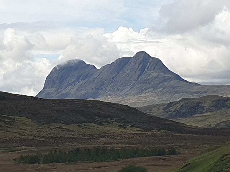
In life there are always ambitions that you wish to achieve. Dave had wanted to climb Suilven, a mountain in Northern Scotland after seeing pictures of it in a book about ten years ago. It has been described by some as the best mountain in Scotland. Suilven, although only 741metres (2389feet) high rises from the wilderness landscape of moor, bogs and small lochs. It is a very distinctive mountain with a steep-sided ridge of almost 2kms, once seen it is definitely never forgotten.
One of the hardest things about Suilven is the journey to reach it, and once arrived the walk is quite a way from the nearest road. After completing The West Highland Way and Ben Nevis we hired a car in Fort William and drove the 4 hours to Lochinver, in Sutherland, the nearest town to Suilven in the far north of Scotland
We stayed at Glencanisp Lodge, this being the closest accommodation to the mountain, about 3 miles down the road from Lochinver. Alternatively stay in Lochinver and either walk down the road, or if you are early enough there is a small car park along the road, about half a mile before Glencanisp lodge. After a delicious breakfast which is served from 7.30am-9.30am, we left the lodge at 9am, leaving our car in the hotel car park. The path to Suilven comes past the hotel and there a rare sign to Suilven is seen. The forecast was mixed, and when we set off the top looked cloudy and windy. The track is easy to follow, and undulates along the valley floor. After about 90 minutes of walking, or 4/5 miles, in the bottom of a dip is a path to the right marked by a cairn, and stones spelling out Suilven artistically arranged on the ground.
The path heads straight towards the middle of the mountain, arriving at a beautiful tarn about thirty minutes later. We followed the path to the right of the tarn, stopping to have a snack and take in the views
The path then begins its very steep ascent of the mountain. Parts of this path have new steps, other parts are quite slippery with bits of rock. Care needs to be taken especially when you are going down. The views get better with every passing step, you are surrounded by views of mountains, lochs and the sea. We continued upwards for 45 minutes until the ridge was reached. Here the view is just exquisite with mountains in all directions.
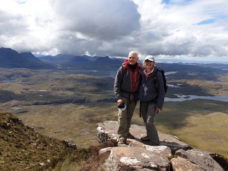
The top to the right is easier to access than the one to the left. So we turned right along the ridge, passing through a gap in the wall and headed for the top. After a further 50 minutes from reaching the ridge we attained the summit (12.50pm) with stupendous views in every direction. This truly is one of the best views we have ever had whilst walking, the cloud level just hovering above the highest mountains adding to the atmosphere.
After lunch, chats and taking many photos we left the top at 1.45pm, we could see rain on the top of a couple of nearby mountains. There are steep drops to each side of the path on the ridge and care does need to be taken. We took our time, as going down seemed to be harder than going up due to the path's terrain and us being distracted by looking at the views. At 3pm we arrived back at the tarn, re-joining the main path at 3.30pm, arriving back at the car at 5pm ahead of the rain.
Comments
This walk even though it is a long 8 hour day does not involve that much altitude Suilven being only 741 meters high. We saw about 30 people all of whom were exhilarated by the sublime views. Some walkers were obviously experienced in walking in the local area (unlike us), and recommended other walks in the vicinity.
We cannot recommend this walk highly enough, even though it is a long way off the beaten track, (for us anyway). It is well worth the drive but ensure that you have a good weather forecast otherwise it would not be worthwhile.
We stayed the following night at a Port A Bhaig Campsite, which has a small shop, shower block, and lovely pub serving food. We intended to summit another iconic mountain Stac Pollaidh the next day. However, the weather had altered overnight with heavy rain, wind and low cloud. We did stop in the car park of Stac Pollaidh, but did not think it would be worthwhile with such bad weather, so we drove south instead sorry to have missed another great walk. Oh well, next time!!
Advice
As always we checked the weather forecast the day before, using BBC weather forecast and Mountain Information Weather Service. http://www.mwis.org.uk/ and https://www.bbc.co.uk/weather
We found the route of the walk and description on https://www.walkhighlands.co.uk/ullapool/suilven.shtml
We also used a map borrowed from the local Library. Ordnance Survey Map Landranger 15 Loch Assynt, Lochinver & Kylesku Map
As always we advise wearing walking boots, taking food, water, wet weather clothes, hats, sun hats, map, compass and first aid kit etc.
Glencanisp Lodge is on Bookings.com and other websites, but after driving down the single track road to find out where the walk was starting from the next day, we just called in and asked for a room - just like the old days. We were lucky as it was their last room, and there were no other rooms available in the vicinity of Lochinver. The building is apparently an old Victorian Hunting Lodge, with friendly staff and beautiful large rooms (albeit without a television). In the main lounge there is a bar with honesty box, television, and of course people to meet. However we had an alternative plan to camp by the sea near Lochinver, (the tent being with us in the car)
I cannot re-iterate enough how much we actually enjoyed this walk. It is well worth the drive, but check the weather first.