


El Cielo, Nerja, Andalucía, Southern Spain
El Cielo (or the sky) at 1508m towers above the town of Nerja, making it easy to access and tempting to climb. This is actually higher than any mountain in the United Kingdom, making it a tough walk, 4 hours up and 4 hours back down if beginning from by the caves of Nerja. It starts on a dusty track, but the walk improves and the views from the top are stupendous, with the coast of Morocco sometimes visible.
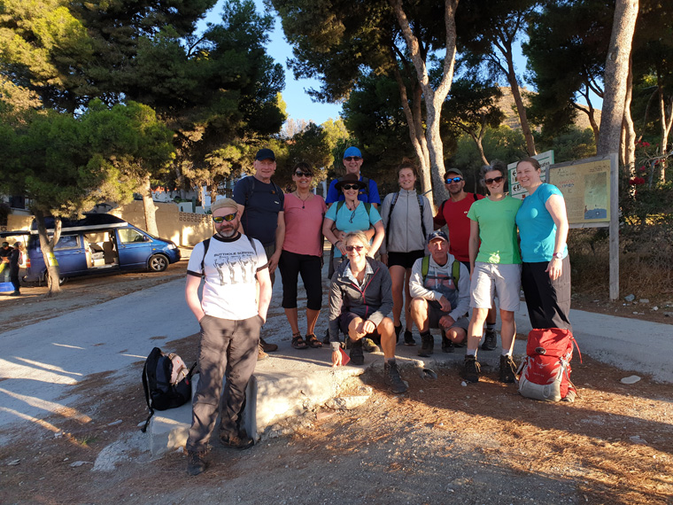
We were staying for a week in Apartment Casanova, Nerja, where we have stayed many times before. It is definitely worthwhile staying in Nerja for at least a few days. There are many walks in the vicinity, as well as fantastic beaches and restaurants. Transport links are good, with a regular bus service to Nerja from both Malaga and Granada. Fifteen friends from Manchester were staying at various apartments in Nerja.
We all caught the 8.45am bus from the bus stop in Nerja, in the direction of Almeria, alighting 15 minutes later at the Nerja Caves, where there are free toilets. It was a beautiful sunny day, and everyone was up for the challenge. There is a notice board with various walks on it, including ours - The Sendero del Pico del Cielo, helpful as this walk is not in any book we have found. We set out following the track that leads from the parking area, passing through the barrier up the valley. In the summer this track is fairly busy with cars driving the couple of miles up to the picnic site. However, in winter when we were there, a locked barrier was down preventing private cars from entering the area. The only vehicles we saw were a lorry coming from the quarry at the top of the track, and much later road-building vehicles. If the barrier was open you could drive a couple of miles, and skip the first section of the walk.
After walking up the road for about 45 minutes we turned right at a sign which says Sendero, the sign to the left saying picnic area. The initial road was dusty and going slightly uphill. At this point the new road becomes steeper. Either the road can be followed or there are sections of path through the pretty pine forest to cut off the hairpin bends. After walking for 2 hours non-stop uphill, the road ends at an unfinished building. There are fantastic views up the coast to the plastic greenhouses in the east, views over Nerja and towards Malaga.
The path now carries on over stony ground between some clumps of trees, where we stopped to rest in the shade. It was sunny but fairly windy, with fantastic views. We did give our friends the option just to stay here and we would pick them up on the way back. Very commendably they all continued, Nick said he had not come this far to give up now. The path had been fairly easy to follow, but half an hour before the summit the path gets a lot steeper, and hard to follow, unless you can find the green arrows and blue spots. Take it easy, some scrambling may be required, to the right the summit can be seen.
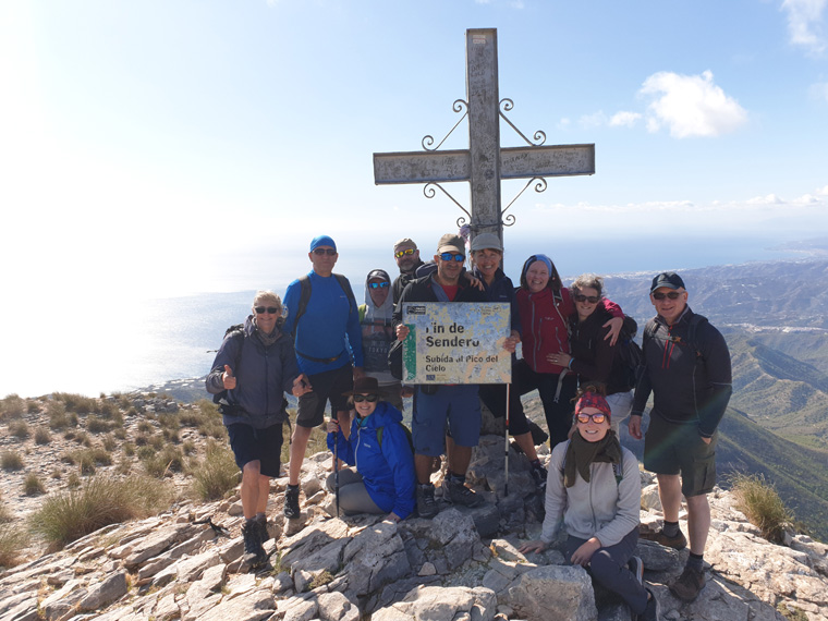
The cross on the top can be seen from quite a distance, but it is fantastic to finally arrive. It was very windy at the top, even with beautiful blue skies, fortunately there is a shelter where we sat to eat our lunch. Spike played the Carpenters' song " Top of the World" on his phone, which was very apt. The view is just fantastic, especially the day we went, with views of the whole of the Costa del Sol between Almunecar and Malaga and many mountains in the distance
Leaving the top at 1.30pm, after many photos, we followed the same path back down. The top section is skiddy with lots of loose rocks, so care needs to be taken. We had boots on, but others wore trainers. It was very windy on the descent and I nearly got blown over. After an hour, we looked back and we could still see the cross on top, after 2 hours we were back at the top of the road. The wind had gone, it was sunny, but with black clouds rolling in. We arrived back at the dusty road at 4.45pm, walking down with the sun shining on the trees. We arrived back at the caves at 5.15pm, just in time for the bus (€1.18 each) at 5.31pm.
It was a great day, with so many lovely friends, we were so impressed that they all made it to the top. The previous day we had completed a 4 hour walk in Frigiliana. They loved that walk so much that 12 of them said they would walk up El Cielo with us the following day. At 1508m it is one of the highest mountains in the area, and much higher than most of them had ever done. We were concerned that they could all make it, being of different walking abilities but they all were very keen and could not be put-off. The night before we had tried to explain to them that it is 4 hours of uphill walking and 3 to 4 hours down the same path. Higher than Snowdon or Ben Nevis, surprisingly no-one would be dissuaded. It was lovely to walk with so many friends.
On returning to Nerja we went for a beer, and on reflection we asked everyone If they would do the walk again. Some would, however our best friend Nick said "Not for 10million pounds".
Distance 12.59miles (20.26km)
Duration of Walk Hours 8.32
Average Pace Min/Mile 40.40
Steps 45653
Elevation gained 4253 feet (1296m)
Information/Advice
Being located in southern Spain, I would advise not doing this walk in the summer months as it would be far too hot, and would require carrying too much water.
Check the weather forecast before setting off, as it would be a shame to walk all this way and have no view. We have been to the top twice before, once with fantastic views, the second time the cloud rolled in -so no view at all.
Take plenty of water (none available en-route), food, sun hats, sun screen, wear walking shoes/boots and mind your step. It was very windy at the top, so always take winter hats and gloves even when it is C25° at the start.
We followed the walk given on the information board by the caves, taking a photo of it. We have not found this walk in any walking books, but it is described on line on various walking sites.
For walks in this area a guide could be hired. Our friends had previously booked walks with John Keo online. John@HikingWalkingSpain.com
We thought this was a fairly straight forward path to follow, except for maybe the final 45 minutes to the top. But last summer a friend's brother climbed El Cielo alone, he ended up lost and spent the night on the mountain. He was found safe and well the following day by the mountain rescue team, that our friend had called out. Be warned.
This is a tough walk, so check sunset and give yourself plenty of time.
We caught the bus, but if arriving by car, park in the car park near the caves, or if the barrier is open, you can drive up the rough road to the right hand junction which says Sendero, saving about 45 minutes (4km) walking each way.
Parking may be an issue during the summer months and at weekends, so arrive early to get a space.
Websites used
https://apartamentos-casanova-nerja.hotelmix.co.uk/
http://mynerja.com/about/nerja-bus-timetables/