


Frigiliana circuit, Nerja, Andalucía, Southern Spain
Frigiliana is a beautiful whitewashed village typical of this area of Andalucía, Southern Spain, 8 km north of the holiday resort of Nerja. It is definitely worthwhile staying here or in Nerja for at least a few days. There are many walks in the vicinity-a brochure is available from the tourist office in the village-as well as fantastic beaches and restaurants. Transport links are great, with a regular bus service to Nerja from both Malaga and Granada.
This walk is shorter than our normal, but incorporates fantastic views of Frigiliana, Nerja and the coast, great scenery and good paths. This is a beautiful day trip, it takes a little over an hour to drive here from Torremolinos/Malaga, alternatively there is a regular bus service or taxi from Nerja, or there is a good choice of hotels and restaurants in the village. Free parking is available along the road, or pay for the multi storey car park.
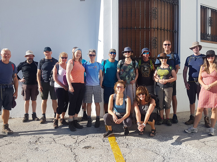
We were staying for a week in Apartment Casanova, Nerja, where we have stayed many times before. Fifteen friends from Manchester were staying at various apartments in Nerja. We all caught the 9.45am bus from the bus stop in Nerja, arriving in the main square in Frigiliana 15 minutes later (€1.30 each).
This walk begins in the main square, (free public toilets) La Plaza del Ingenio, turning down the side of Unicaja Bank, with signs for GR242 and GR249, following a small concrete road down to the dried-up river bed. Turning left here follow the right bank, and after 15 minutes arrive at a white box where water can be heard running underneath. Turn right following the signpost to Nerja 13.4 km. We climbed steadily to the top of the ridge, through the beautiful pine trees, taking us 35 minutes after leaving the village. It is worth the walk up here for the beautiful views and peace alone. Ignoring the GR247 sign to the left, we turned right along the ridge, following a few blue spots and small cairns found along the way.
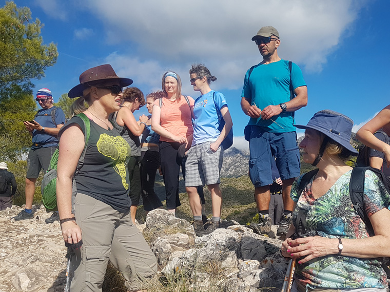
Ten minutes later we came to a massive circular cairn on the ridge top, marking the highest point of the walk. The views from here are quite breathtaking back over the mountains, over Nerja and Frigiliana.
Fifteen minutes later we arrived at a small cairn, apparently from here there is a path on the right back to Frigiliana but there were no signposts. (Not that we were going that way). We carried straight on under a pylon, angling right then angling left. Do not go down the rough road. We turned left passing an old blue water butt on the right, after the final climb of ten minutes we reached our destination of Cruz de Pinto, with truly sublime views all around. We spent some time here, sitting on the bench, and taking many photos. The views and blue skies were spectacular. The small shrine of Cruz de Pinto was built in 1643, following a sailing ship commanded by Francisco de Pinto being saved in a storm.
From the cross we turned left for 40m to the cairn, then turned right. We followed the lovely path downhill reaching a concrete road 20 minutes later next to signs saying Parque Natural 20. Turning left for 200m, then right by the sign for Quito Pinto, ten minutes later we came to the valley floor with cliffs towering over us and new buildings perched on the top. At this point if there has been heavy rain and the river is flowing fast it may be prudent to change route here, crossing the river, climbing the track, then following the main road back to Frigiliana. However, when we were there the river was completely dry, so we continued following a track on the right, past some red roofed buildings into the gorge.
Now the walk becomes really exciting, the Higueron gorge becoming very narrow at this point, in parts with our arms outstretched we could nearly touch both walls at the same time. We took the steep concrete steps to the right by a fig tree. The path varies between being in the river (fortunately dry) and to the right, sometimes with a steep drop down from the path. After 30 minutes we reached the river bed below the village, where we had crossed it previously. Turning left by a marker post with red and white stripes on, we walked up the steep path back into village arriving 3 and a half hours after leaving.
This is a lovely walk, we had beautiful weather for the first week of November, definitely to be recommended. As this was a relatively short walk, we took our time, enjoying the moment, and ate our lunch en route.
Our friends all loved the walk, so much so that 12 of them said they would walk up El Cielo the following day. At 1508m it is one of the highest mountains in the area, and much higher than some of them had ever done. We were concerned that they could all make, but they all were very keen and could not be dissuaded. Time will tell.
Distance 4.34miles (6.98km)
Duration of Walk Hours 3.50
Average Pace Min/Mile 48.14
Steps 17821
Elevation gained 1237 feet (377m)
Information/Advice
Like all walks in Spain we recommend taking lots of water with you, none was available on this walk, the only spring being dried up, as well sun hats, sun tan lotion, food, sun glasses - for the glare of the sun off the rocks etc.
We wore our walking boots, but others that we were with wore walking shoes or trainers.
Long trousers could be necessary to protect legs from thorny bushes, but in November when we walked in shorts we had no problem.
If arriving by car, parking could be issue during the summer months and at weekends, so arrive early to get a space. Again the busses could fill up quickly. We were here in the first week of November and the afternoon bus back to Nerja was full.
Take care if there has been heavy rain or a sudden storm, and the river is flowing fast, it may be prudent to change route at the second crossing of the river after visiting the cross. Cross the river, climb the track then following the main road back to Frigiliana. However, when we were there the river was completely dry,
This area of Southern Spain is accessible from England either by driving through France and Spain, or flying to Malaga then hiring a car or the route that we took driving from our home in Manchester then catching the 24 hour relaxing ferry from Plymouth to Santander, then touring through Spain.
Resources Used
Coastal Walks in Andalucía by Guy Hunter-Davies Walk 31 Cicerone press
Brochure in English from the tourist office in Frigiliana €2. This contains 9 walks from the village, the above walk is a combination of a couple of them.
Websites used
https://www.brittany-ferries.co.uk/
http://mynerja.com/about/nerja-bus-timetables/
Frigiliana circuit, Nerja, Andalucía, Southern Spain
Frigiliana is a beautiful whitewashed village typical of this area of Andalucía, Southern Spain, 8 km north of the holiday resort of Nerja. It is definitely worthwhile staying here or in Nerja for at least a few days. There are many walks in the vicinity-a brochure is available from the tourist office in the village-as well as fantastic beaches and restaurants. Transport links are great, with a regular bus service to Nerja from both Malaga and Granada.
This walk is shorter than our normal, but incorporates fantastic views of Frigiliana, Nerja and the coast, great scenery and good paths. This is a beautiful day trip, it takes a little over an hour to drive here from Torremolinos/Malaga, alternatively there is a regular bus service or taxi from Nerja, or there is a good choice of hotels and restaurants in the village. Free parking is available along the road, or pay for the multi storey car park.
We were staying for a week in Apartment Casanova, Nerja, where we have stayed many times before. Fifteen friends from Manchester were staying at various apartments in Nerja. We all caught the 9.45am bus from the bus stop in Nerja, arriving in the main square in Frigiliana 15 minutes later (€1.30 each).
This walk begins in the main square, (free public toilets) La Plaza del Ingenio, turning down the side of Unicaja Bank, with signs for GR242 and GR249, following a small concrete road down to the dried-up river bed. Turning left here follow the right bank, and after 15 minutes arrive at a white box where water can be heard running underneath. Turn right following the signpost to Nerja 13.4 km. We climbed steadily to the top of the ridge, through the beautiful pine trees, taking us 35 minutes after leaving the village. It is worth the walk up here for the beautiful views and peace alone. Ignoring the GR247 sign to the left, we turned right along the ridge, following a few blue spots and small cairns found along the way.
Ten minutes later we came to a massive circular cairn on the ridge top, marking the highest point of the walk. The views from here are quite breathtaking back over the mountains, over Nerja and Frigiliana.
Fifteen minutes later we arrived at a small cairn, apparently from here there is a path on the right back to Frigiliana but there were no signposts. (Not that we were going that way). We carried straight on under a pylon, angling right then angling left. Do not go down the rough road. We turned left passing an old blue water butt on the right, after the final climb of ten minutes we reached our destination of Cruz de Pinto, with truly sublime views all around. We spent some time here, sitting on the bench, and taking many photos. The views and blue skies were spectacular. The small shrine of Cruz de Pinto was built in 1643, following a sailing ship commanded by Francisco de Pinto being saved in a storm.
From the cross we turned left for 40m to the cairn, then turned right. We followed the lovely path downhill reaching a concrete road 20 minutes later next to signs saying Parque Natural 20. Turning left for 200m, then right by the sign for Quito Pinto, ten minutes later we came to the valley floor with cliffs towering over us and new buildings perched on the top. At this point if there has been heavy rain and the river is flowing fast it may be prudent to change route here, crossing the river, climbing the track, then following the main road back to Frigiliana. However, when we were there the river was completely dry, so we continued following a track on the right, past some red roofed buildings into the gorge.
Now the walk becomes really exciting, the Higueron gorge becoming very narrow at this point, in parts with our arms outstretched we could nearly touch both walls at the same time. We took the steep concrete steps to the right by a fig tree. The path varies between being in the river (fortunately dry) and to the right, sometimes with a steep drop down from the path. After 30 minutes we reached the river bed below the village, where we had crossed it previously. Turning left by a marker post with red and white stripes on, we walked up the steep path back into village arriving 3 and a half hours after leaving.
This is a lovely walk, we had beautiful weather for the first week of November, definitely to be recommended. As this was a relatively short walk, we took our time, enjoying the moment, and ate our lunch en route.
Our friends all loved the walk, so much so that 12 of them said they would walk up El Cielo the following day. At 1508m it is one of the highest mountains in the area, and much higher than some of them had ever done. We were concerned that they could all make, but they all were very keen and could not be dissuaded. Time will tell.
Distance 4.34miles (6.98km)
Duration of Walk Hours 3.50
Average Pace Min/Mile 48.14
Steps 17821
Elevation gained 1237 feet (377m)
Information/Advice
Like all walks in Spain we recommend taking lots of water with you, none was available on this walk, the only spring being dried up, as well sun hats, sun tan lotion, food, sun glasses - for the glare of the sun off the rocks etc.
We wore our walking boots, but others that we were with wore walking shoes or trainers.
Long trousers could be necessary to protect legs from thorny bushes, but in November when we walked in shorts we had no problem.
If arriving by car, parking could be issue during the summer months and at weekends, so arrive early to get a space. Again the busses could fill up quickly. We were here in the first week of November and the afternoon bus back to Nerja was full.
Take care if there has been heavy rain or a sudden storm, and the river is flowing fast, it may be prudent to change route at the second crossing of the river after visiting the cross. Cross the river, climb the track then following the main road back to Frigiliana. However, when we were there the river was completely dry,
This area of Southern Spain is accessible from England either by driving through France and Spain, or flying to Malaga then hiring a car or the route that we took driving from our home in Manchester then catching the 24 hour relaxing ferry from Plymouth to Santander, then touring through Spain.
Resources Used
Coastal Walks in Andalucía by Guy Hunter-Davies Walk 31 Cicerone press
Brochure in English from the tourist office in Frigiliana €2. This contains 9 walks from the village, the above walk is a combination of a couple of them.
Websites used
https://www.mapmywalk.com/
https://www.bbc.co.uk/weather
https://www.brittany-ferries.co.uk/
http://mynerja.com/about/nerja-bus-timetables/