


Kinder Scout, Edale Valley, Derbyshire, England
Today's challenge was admittedly not as hard as usual, but we just fancied a quick run out. We usually walk up Kinder Scout from Hayfield, but this time we decided to ascend from Edale village instead. Edale is a beautiful village, situated in a very pretty valley. It is easily accessible from our home in Manchester by car or train. The whole area of Edale, Castleton, Hope and Hathersage is very pretty, with many lovely pubs/cafes and lots of accommodation. Due to the popularity the car parks do fill up quickly, alternatively there is a train from Sheffield or Manchester.
We arrived in Edale later than we normally do, and this being a Sunday in May the large car park (with toilets) near the station was full. Fortunately for us, 28 days of the year a nearby field is available for parking, with a donation of £5 given to local charities being placed in a milk churn.
We followed the path for a couple of minutes back to the village, passing The Rambler Inn, a beautiful church, then Fieldhead campsite with a national park centre, toilet, and very useful shop, which sells maps, walking equipment etc. At the head of Edale village is another campsite, Cooper's cafe, small shop and a very famous pub, the Old Nags Head where the Pennine Way walk officially begins.
We continued up the road. Five minutes later there is a footpath on the right leading down over a stream, signposted to Moorland and Grindsbrook, with steps up the other side. This is a beautiful area with the side of Kinder Scout coming into full view. After ten minutes this path splits, the more popular route goes left up Grindsbrook Clough, we have walked this before and found it to be rough and very rocky underfoot and quite hard going before reaching the ridge. We therefore took the right hand path, to the top of Ringing Roger, (the echoing rocks) arriving there an hour after leaving the car. This is an obvious path which steeply ascends to the top. The views were fantastic over to Win Hill, Lose Hill, Mam Tor and the Edale Valley.
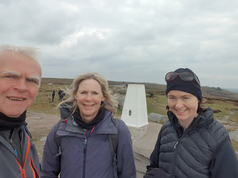
After reaching the ridge we turned left (west), reaching the top of Grindsbrook 45 minutes later. From a large cairn here an indistinct path strikes out to the right across the plateau to Kinder Downfall, we tried this route once and got very lost, as there are no obvious landmarks to follow and many peat bogs. On this occasion we carried on along the ridge following the obvious path, past many interesting gritstone rock formations. These are definitely worth a good look at, and many great photos can be taken using the valley as a backdrop. The path continues along to the head of the valley. Just before this is reached, there is a path to the right which after 5 minutes takes you to the actual trig point of Kinder Scout at 631m. It is worth taking this small diversion with great views over Manchester and Cheshire, sometimes the hills of Wales can be seen.
Returning to our path we carried on to the top of the valley, then deciding that the weather was too cold to make the walk fun, decided to go down Jacobs Ladder back to Edale. This path is well maintained being part of the Pennine Way coming up from Edale. We descended down some steps, eventually going over a beautiful old packhorse bridge. The path comes to a farm, and after going through the farm gate, make sure you check out the lovely display of Edale Valley life in the old cow sheds on the right. We then followed signs along the undulating path on the valley floor back into Edale.
The whole walk took us 5 hours, covering nine miles. The weather was inclement, cold and windy for May. We went for tea and cake at Cooper's cafe. It is a very beautiful walk, and fairly easily accessible, with many people out. Another day we would have continued past Crowden Tower, along Rushup Edge, over Mam Tor and finally back to Edale, but it was just too cold to be enjoyable. We were glad to have taken our winter hats and gloves. The weather is usually unpredictable on the top, it was May Day bank holiday, we have worn shorts in March, and winter coats in August when we once got caught in a hail storm.
We have been up Kinder Scout many times, there are so many different routes, round the head of the valley, round the plateau, a figure of 8 loop from Hayfield to Edale and back etc
Information/Advice
As usual wear boots, take a phone, sun hats, sun tan lotion, and plenty of food and water as after leaving the start nothing is available. It can also be very cold on the top, especially if it's windy or the clouds roll in, so take a wind proof jacket and warm hat and gloves.
Check the weather forecast before setting off.
Distance 9.45 miles (15.20km)
Duration of Walk 5 Hours 10mins
Average Pace Min/Mile 32
Steps 29414
Elevation Gained 1684 feet (513m)
Resources Used
Because this is an area that we know well we don't tend to use any resources. But these could be used:-
Ordnance Survey The Peak District- Dark area OL1- only part of the walk is on this map
AA Book 50 walks in Derbyshire by John Gillham. Walk 8 and Walk 9
Walking brochures are also available in Fieldhead campsite shop-if this is open.
Websites used