


Tegg's Nose, Macclesfield Forest, and Shutlingsloe Circuit, Cheshire
This area in East Cheshire is very popular, as it is a lovely area with forest, moors, some elevation and great views, and due to its location just south of Stockport and Greater Manchester. The walk begins at the car park at Tegg's Nose Country Park, 350m (1148feet), found just off the A537 Macclesfield to Buxton (Cat and the Fiddle road). At the weekend arrive early otherwise parking can be a problem. We were there on a Friday in March so it was nice and quiet. Just remember to take change for the car park (£3.50), as the machine does not take cards. There is a cafe and toilets.
After admiring the views and reading the information boards we left the car park at 9.30am and headed downhill following the signed Saddlers Way Track and our first destination Forest Chapel. Then turned right along the tarmacked road past Clough House following the small lane to Hardingland, 200m later we went right, through a gate to enter Macclesfield Forest. Climbing up through the forest there is a bench to rest on. The trees part to give beautiful views to Shutlingsloe, the tower at Wincle, then to Shining Tor and the Cat and the Fiddle pub.
We descended the forest track to Forest Chapel (Saint Stephen's Church), taking a slight detour to the left to visit this beautiful remote church. It was built in 1673, and then reconstructed in 1831 and is still used for services. Check it out together with the interesting cemetery, apparently it has a regular congregation of 20 people. Leaving at 10.30am we followed the road straight on from where we had arrived (not past the church).
At a road junction we went right, before arriving at a car park. At this point we left the road, went through a gate following the obvious path, climbing past trees, out onto moorland, before joining the path we normally take coming up from Trentabank Reservoir/Macclesfield Forest. Just before the summit there is a stile over a wall, then a choice of routes either a very steep path or to the left there is a longer gentler path.
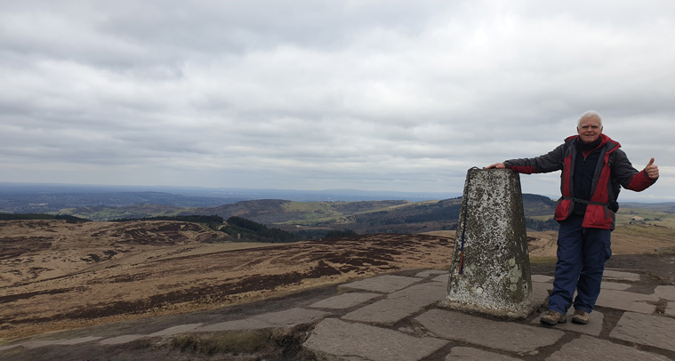
We arrived at the very windy top of Shutlingsloe 506m (1670ft) complete with trig point at 11.30am, (2 hours after leaving our car). We sat for a while eating our lunch with tremendous views over Cheshire, Derbyshire and parts of Staffordshire. We ate quickly as it was rather chilly. Leaving in an easterly direction (the opposite to the way in which we had come), down a very steep slope, turning right along a tarmac track, right again along the road, then reached the Crag Inn Pub, at Wildboarclough-a very exciting name!!.
At the far end of the pub car park is a footpath that could be taken to Lower Nabbs Farm, re-joining the road at Greenway Bridge. However, we decided as the road was so quiet just to continue on the road. The road eventually splits, we followed the sign saying Cheshire cycleway to Oakenclough then to Haddon farm. There are great views back to Shutlingsloe and towards our destination Tegg's Nose. On the right hand side of the path is a very interesting upright old stone, with a symbol of a shell carved in it, and a date that we could not read-interesting.
Reaching the main road we turned right then passed the Hanging Gate Inn-which has a superb outdoor area-with excellent views. Check out the pub sign too, unfortunately closed when we were there. We took the small footpath to the right hand side of the pub, turning left down Meg Lane. Then after a couple of 100m, we turned right (north) along the Gritstone Trail-a path that we have taken before in the opposite direction. We past the very interesting buildings at Bollin Head Farm, and the old red letter box, continuing until we turned left down Clarke Lane (2pm).
We crossed the dams over Bottoms and Tegg's Nose reservoirs. They were built in 1850 and 1871 respectively in order to regulate the flow of the River Bollin feeding the textile and silk mills of Macclesfield.
It was still quite a climb up to Tegg's Nose, the clearly marked path passing through the now abandoned quarry. Take time to study the notice boards and old machinery. Quarrying started here in the 1500s and continued for about 500 years. The rocks were used for a variety of purposes-roads, buildings, and roofing. We arrived back in the car park at 3pm, in time to have a delicious well-earned hot chocolate from the cafe.
Distance 11.5 miles (18.7 km)
Duration of Walk 5.20 Hours
Elevation 2046 feet (623m)
Average Pace min/mile 27
Comments
We really enjoyed this walk, the weather was great, if a bit windy and the views were tremendous, surrounded by beautiful countryside.
As always we advise wearing walking boots- we wear Lowa. The weather in this area can be changeable, so take wet weather clothes, hats, sun hats, map, compass and first aid kit etc. Take a phone charger, especially if using on-line resources. Also take food and drink, but if open call in the Crag Inn or Hanging Gate Inn.
Saddlers Way is part of old packhorse routes, popular around Cheshire and the Pennines. Before modern roads were built these were essential supply routes. Goods such as salt, wool, stone, coal and cloth being transported by packhorses. Sometimes the path is deeply cut into the landscape, showing its great age and use.
Shutlingsloe, due to its shape is sometimes called the Matterhorn of Cheshire. Twenty thousand years ago the summit of it stuck out of the surrounding ice sheet, which subsequently melted.
Macclesfield Forest was once part of a large Royal hunting ground. Red deer, Ravens, Buzzards and Pied Wagtails, can sometimes be seen.
Resources Used
My new favourite thing is ordnance survey maps online. I paid £30 for the year and downloaded the App onto my phone. The maps then cover all of England, Wales and Scotland.
Ordnance Survey Map 24 Peak District - White Peak area.
Cheshire walks OS Pathfinder guide book by Brian Conduit, part of walk numbers 27 and 28.
Websites Used
https://steve-parker.org/articles/cheshire_three_peaks/
https://osmaps.ordnancesurvey.co.uk/
https://www.visitcheshire.com/things-to-do/the-gritstone-trail-p49561
www.bbc.co.uk/weather
We used https://www.mapmywalk.com/ to record the walk.
http://hikingwithdaveandbarbara.com/gritstone.html check out our website of our walk of the Gritstone Trail.
Further Information
Tegg's Nose
https://bustimes.org/services/60030859 Buses to Tegg's Nose